IMAGES TAKEN NEAR TO
Cannonfields, BURY ST. EDMUNDS, IP33 1JX
Introduction
This page details the photographs taken nearby to Cannonfields, IP33 1JX by members of the Geograph project.
The Geograph project started in 2005 with the aim of publishing, organising and preserving representative images for every square kilometre of Great Britain, Ireland and the Isle of Man.

There are currently over 7.5m images from over14,400 individuals and you can help contribute to the project by visiting https://www.geograph.org.uk
Image Map
Images are licensed for reuse under creativecommons.org/licenses/by-sa/2.0
Notes
- Clicking on the map will re-center to the selected point.
- The higher the marker number, the further away the image location is from the centre of the postcode.
Image Listing (458 Images Found)
Images are licensed for reuse under creativecommons.org/licenses/by-sa/2.0
Image
Details
Distance
1
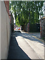
Cadney Lane
A turning off Northgate Street.
Image: © John Goldsmith
Taken: 4 Jun 2010
0.02 miles
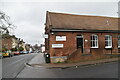
2
![Bury St Edmunds buildings [196]](https://s2.geograph.org.uk/geophotos/06/69/07/6690786_d6747ed8_120x120.jpg)
Bury St Edmunds buildings [196]
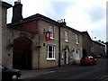
The Old Cannon Brewery at number 86 Cannon Street is public house and micro brewery. Previously named the St Edmunds Head it opened circa 1845. Built in the mid 19th century with a white brick front and red brick sides and rear. There is an attached stable block which had room for 24 horses but has been converted to living accommodation. Listed, grade II, with details at: https://historicengland.org.uk/listing/the-list/list-entry/1248044
North of the town centre Northgate Street and St John’s Street run towards the site of Northgate and the railway station and both streets have many older buildings. In between these two streets is a number of streets irregularly laid out (compared to the medieval grid of the town centre) containing mostly houses and buildings from the 19th century.
Bury St Edmunds is a market town which is the cultural and retail centre for West Suffolk and is known for brewing (Greene King) and sugar (British Sugar). There is scattered evidence of earlier activity but essentially Bury St Edmunds began as one of the royal boroughs of the Saxons and a monastery was founded which became the burial place of King Edmund. A new Benedictine abbey was built in 1020 which became rich and powerful and the town was laid out on a grid pattern by Abbot Baldwin. After the dissolution the abbey became ruinous. A new church, later the cathedral, was begun in the early 16th century.
Image: © Michael Dibb
Taken: 10 Sep 2020
0.02 miles
4
![Bury St Edmunds houses [260]](https://s3.geograph.org.uk/geophotos/06/69/22/6692247_b3851b53_120x120.jpg)
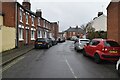
Bury St Edmunds houses [260]
Numbers 25, 26 and 27 Northgate Street are a row of three early 19th century houses. Partly timber framed with roughcast fronts, red brick to the side of number 25, flint and stone blocks to the side of number 27. Numbers 26 and 27 are a matching pair, number 25 is a slightly later addition. Listed, for group value, grade II, with details at: https://historicengland.org.uk/listing/the-list/list-entry/1022638
North of the town centre Northgate Street and St John’s Street run towards the site of Northgate and the railway station and both streets have many older buildings. In between these two streets is a number of streets irregularly laid out (compared to the medieval grid of the town centre) containing mostly houses and buildings from the 19th century.
Bury St Edmunds is a market town which is the cultural and retail centre for West Suffolk and is known for brewing (Greene King) and sugar (British Sugar). There is scattered evidence of earlier activity but essentially Bury St Edmunds began as one of the royal boroughs of the Saxons and a monastery was founded which became the burial place of King Edmund. A new Benedictine abbey was built in 1020 which became rich and powerful and the town was laid out on a grid pattern by Abbot Baldwin. After the dissolution the abbey became ruinous. A new church, later the cathedral, was begun in the early 16th century.
Image: © Michael Dibb
Taken: 10 Sep 2020
0.03 miles
5
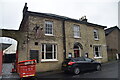
The Old Cannon
The Old Cannon Brewery, Bar, Brasserie and Bed & Breakfast.
http://www.oldcannonbrewery.co.uk/
Image: © Tim Marchant
Taken: 17 Nov 2010
0.03 miles
8
![Bury St Edmunds houses [261]](https://s0.geograph.org.uk/geophotos/06/69/22/6692248_2c7745e4_120x120.jpg)
Bury St Edmunds houses [261]
Number 28 Northgate Street is early 19th century with white brick to the front, red brick to the sides and rear. The entrance door is set within a Corinthian portico. Listed, grade II, with details at: https://historicengland.org.uk/listing/the-list/list-entry/1022641
North of the town centre Northgate Street and St John’s Street run towards the site of Northgate and the railway station and both streets have many older buildings. In between these two streets is a number of streets irregularly laid out (compared to the medieval grid of the town centre) containing mostly houses and buildings from the 19th century.
Bury St Edmunds is a market town which is the cultural and retail centre for West Suffolk and is known for brewing (Greene King) and sugar (British Sugar). There is scattered evidence of earlier activity but essentially Bury St Edmunds began as one of the royal boroughs of the Saxons and a monastery was founded which became the burial place of King Edmund. A new Benedictine abbey was built in 1020 which became rich and powerful and the town was laid out on a grid pattern by Abbot Baldwin. After the dissolution the abbey became ruinous. A new church, later the cathedral, was begun in the early 16th century.
Image: © Michael Dibb
Taken: 10 Sep 2020
0.04 miles
9
![Bury St Edmunds houses [250]](https://s0.geograph.org.uk/geophotos/06/69/07/6690780_42b89ac4_120x120.jpg)
Bury St Edmunds houses [250]
Numbers 37, 38 and 39 Cannon Street are a row of three houses. The houses contain the remains of a 13th century aisled house much altered in the 17th century and later. Timber framed and stuccoed with early 19th century fronts to numbers 37 and 38 and a modern front to number 39. Listed, grade II, with details at: https://historicengland.org.uk/listing/the-list/list-entry/1248040
North of the town centre Northgate Street and St John’s Street run towards the site of Northgate and the railway station and both streets have many older buildings. In between these two streets is a number of streets irregularly laid out (compared to the medieval grid of the town centre) containing mostly houses and buildings from the 19th century.
Bury St Edmunds is a market town which is the cultural and retail centre for West Suffolk and is known for brewing (Greene King) and sugar (British Sugar). There is scattered evidence of earlier activity but essentially Bury St Edmunds began as one of the royal boroughs of the Saxons and a monastery was founded which became the burial place of King Edmund. A new Benedictine abbey was built in 1020 which became rich and powerful and the town was laid out on a grid pattern by Abbot Baldwin. After the dissolution the abbey became ruinous. A new church, later the cathedral, was begun in the early 16th century.
Image: © Michael Dibb
Taken: 10 Sep 2020
0.04 miles
10
![Bury St Edmunds buildings [202]](https://s2.geograph.org.uk/geophotos/06/69/22/6692246_baeb69cd_120x120.jpg)
Bury St Edmunds buildings [202]
Now known as St Michael's Close, this building was the King Edward VI Grammar School from 1664 to 1883 and then a girls' boarding school until 1939. Converted into flats circa 1945. The older part (furthest from the camera) is 17th century, the newer part is 18th century. The building is timber framed and stuccoed in panels. There were alterations and extensions in the 19th century. There is another view of the building at Image Listed, grade II*, with details at: https://historicengland.org.uk/listing/the-list/list-entry/1022633
North of the town centre Northgate Street and St John’s Street run towards the site of Northgate and the railway station and both streets have many older buildings. In between these two streets is a number of streets irregularly laid out (compared to the medieval grid of the town centre) containing mostly houses and buildings from the 19th century.
Bury St Edmunds is a market town which is the cultural and retail centre for West Suffolk and is known for brewing (Greene King) and sugar (British Sugar). There is scattered evidence of earlier activity but essentially Bury St Edmunds began as one of the royal boroughs of the Saxons and a monastery was founded which became the burial place of King Edmund. A new Benedictine abbey was built in 1020 which became rich and powerful and the town was laid out on a grid pattern by Abbot Baldwin. After the dissolution the abbey became ruinous. A new church, later the cathedral, was begun in the early 16th century.
Image: © Michael Dibb
Taken: 10 Sep 2020
0.04 miles