
IMAGES TAKEN NEAR TO
Skinner Street, BURY ST. EDMUNDS, IP33 1DD
Introduction
This page details the photographs taken nearby to Skinner Street, IP33 1DD by members of the Geograph project.
The Geograph project started in 2005 with the aim of publishing, organising and preserving representative images for every square kilometre of Great Britain, Ireland and the Isle of Man.

There are currently over 7.5m images from over14,400 individuals and you can help contribute to the project by visiting https://www.geograph.org.uk
Image Map
Images are licensed for reuse under creativecommons.org/licenses/by-sa/2.0
Notes
- Clicking on the map will re-center to the selected point.
- The higher the marker number, the further away the image location is from the centre of the postcode.
Image Listing (1635 Images Found)
Images are licensed for reuse under creativecommons.org/licenses/by-sa/2.0
Image
Details
Distance
1

Street cleaning, Bury St Edmunds
This 'graffiti and gum remover' is using a high temperature, low pressure steam system which not only removes the gum but also the oily stain that can remain after traditional high pressure systems have been employed. See http://www.street-smart.co.uk/index.htm
Image: © Bob Jones
Taken: 18 Mar 2009
0.00 miles
2
![Bury St Edmunds buildings [106]](https://s1.geograph.org.uk/geophotos/06/66/61/6666137_bf72183d_120x120.jpg)
Bury St Edmunds buildings [106]
Numbers 14 and 15 Buttermarket are a single building divided into two shops with storage above. Early 19th century, timber framed and stuccoed. The first storey windows are very irregular. Listed, for group value, with details at: https://historicengland.org.uk/listing/the-list/list-entry/1031139
Cornhill, Buttermarket and The Traverse are the commercial heart of the town. Cornhill incorporates the market areas set out in the 12th century where twice weekly markets are held, Buttermarket with The Traverse extend to the south connecting with Abbeygate Street and Guildhall Street. The area has some of the town’s finest and most important buildings.
Bury St Edmunds is a market town which is the cultural and retail centre for West Suffolk and is known for brewing (Greene King) and sugar (British Sugar). There is scattered evidence of earlier activity but essentially Bury St Edmunds began as one of the royal boroughs of the Saxons and a monastery was founded which became the burial place of King Edmund. A new Benedictine abbey was built in 1020 which became rich and powerful and the town was laid out on a grid pattern by Abbot Baldwin. After the dissolution the abbey became ruinous. A new church, later the cathedral, was begun in the early 16th century.
Image: © Michael Dibb
Taken: 14 Sep 2020
0.00 miles
3
![Bury St Edmunds buildings [104]](https://s3.geograph.org.uk/geophotos/06/66/61/6666135_d3ebc040_120x120.jpg)
Bury St Edmunds buildings [104]
In the 1970s, number 12 and number 13 Buttermarket were joined together as one large shop. Now re-divided into three shops with storage above. Number 12 (seen here) is early or mid 19th century, timber framed and stuccoed with two 20th century shop fronts. Number 13 Buttermarket Image is early to mid 19th century, timber framed and stuccoed with one large 20th century shop front. Listed, mainly for group value, grade II, with details at: https://historicengland.org.uk/listing/the-list/list-entry/1031136
Cornhill, Buttermarket and The Traverse are the commercial heart of the town. Cornhill incorporates the market areas set out in the 12th century where twice weekly markets are held, Buttermarket with The Traverse extend to the south connecting with Abbeygate Street and Guildhall Street. The area has some of the town’s finest and most important buildings.
Bury St Edmunds is a market town which is the cultural and retail centre for West Suffolk and is known for brewing (Greene King) and sugar (British Sugar). There is scattered evidence of earlier activity but essentially Bury St Edmunds began as one of the royal boroughs of the Saxons and a monastery was founded which became the burial place of King Edmund. A new Benedictine abbey was built in 1020 which became rich and powerful and the town was laid out on a grid pattern by Abbot Baldwin. After the dissolution the abbey became ruinous. A new church, later the cathedral, was begun in the early 16th century.
Image: © Michael Dibb
Taken: 14 Sep 2020
0.01 miles

5
![Bury St Edmunds buildings [105]](https://s0.geograph.org.uk/geophotos/06/66/61/6666136_45813ee6_120x120.jpg)
Bury St Edmunds buildings [105]
In the 1970s, number 12 and number 13 Buttermarket were joined together as one large shop. Now re-divided into three shops with storage above. Number 13 (seen here) is early to mid 19th century, timber framed and stuccoed with one large 20th century shop front. Number 12 Buttermarket Image is early or mid 19th century, timber framed and stuccoed with two 20th century shop fronts. Listed, mainly for group value, grade II, with details at: https://historicengland.org.uk/listing/the-list/list-entry/1031136
Cornhill, Buttermarket and The Traverse are the commercial heart of the town. Cornhill incorporates the market areas set out in the 12th century where twice weekly markets are held, Buttermarket with The Traverse extend to the south connecting with Abbeygate Street and Guildhall Street. The area has some of the town’s finest and most important buildings.
Bury St Edmunds is a market town which is the cultural and retail centre for West Suffolk and is known for brewing (Greene King) and sugar (British Sugar). There is scattered evidence of earlier activity but essentially Bury St Edmunds began as one of the royal boroughs of the Saxons and a monastery was founded which became the burial place of King Edmund. A new Benedictine abbey was built in 1020 which became rich and powerful and the town was laid out on a grid pattern by Abbot Baldwin. After the dissolution the abbey became ruinous. A new church, later the cathedral, was begun in the early 16th century.
Image: © Michael Dibb
Taken: 14 Sep 2020
0.01 miles

7

Once a fire station, now a bank
This former fire station in the centre of Bury St Edmunds (see inscription above the entrance) is now a branch of the Halifax Bank.
Image: © Bob Jones
Taken: 20 Feb 2009
0.01 miles
8

The Cornhill on a Saturday
Market stalls and shoppers on a Saturday in December 2010
Image: © Chris Holifield
Taken: 11 Dec 2010
0.01 miles
9
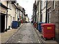
"Bin Alley" in Bury St Edmunds
A view south along Skinner Street
Image: © Richard Humphrey
Taken: 21 Jun 2020
0.01 miles
10

The town's second corn exchange
Erected in 1836, but already too small by 1861 to suit the needs of the Bury St Edmunds corn merchants,(who simply put up a bigger one right next door) the building acquired a number of functions over the following years, including fire station, school of art and library.
Image: © Stuart Shepherd
Taken: 10 Nov 2007
0.01 miles