IMAGES TAKEN NEAR TO
Prigmore Drive, IP32 7QR
Introduction
This page details the photographs taken nearby to Prigmore Drive, IP32 7QR by members of the Geograph project.
The Geograph project started in 2005 with the aim of publishing, organising and preserving representative images for every square kilometre of Great Britain, Ireland and the Isle of Man.

There are currently over 7.5m images from over14,400 individuals and you can help contribute to the project by visiting https://www.geograph.org.uk
Image Map
Images are licensed for reuse under creativecommons.org/licenses/by-sa/2.0
Notes
- Clicking on the map will re-center to the selected point.
- The higher the marker number, the further away the image location is from the centre of the postcode.
Image Listing (33 Images Found)
Images are licensed for reuse under creativecommons.org/licenses/by-sa/2.0
Image
Details
Distance
1
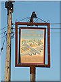
Flying Fortress Pub Sign
Pub sign for the Flying Fortress near to Bury St. Edmunds, Suffolk. For view of the pub and its history see http://www.geograph.org.uk/photo/1293851
Image: © Keith Evans
Taken: 8 May 2009
0.04 miles
2

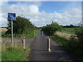
National Cycle Route 51
This is route 51 of the National Cycle network, seen here crossing the entrance to the Flying Fortress pub.
Image: © Greg Aspland
Taken: 18 Oct 2008
0.04 miles
3

Sign for the Flying Fortress, Bury St Edmunds
Image: © JThomas
Taken: 14 Sep 2015
0.05 miles
4
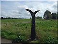
Millennium milepost, National Cycle Route 13
Image: © JThomas
Taken: 14 Sep 2015
0.05 miles
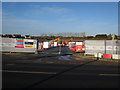
6
Moreton Hall expansion
A major, ongoing, expansion of Bury St. Edmunds.
Image: © Hugh Venables
Taken: 22 Dec 2016
0.07 miles
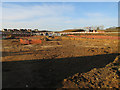
7
More Moreton Hall
A major, ongoing, expansion of Bury St. Edmunds.
Image: © Hugh Venables
Taken: 22 Dec 2016
0.08 miles
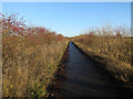
8
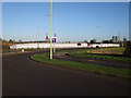
Cycle route across the railway
With Moreton Hall development ongoing.
Image: © Hugh Venables
Taken: 22 Dec 2016
0.09 miles
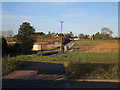
10
National cycle route 51
Between Bury St. Edmunds and Thurston.
Image: © Hugh Venables
Taken: 22 Dec 2016
0.10 miles