IMAGES TAKEN NEAR TO
Chamberlayne Road, BURY ST. EDMUNDS, IP32 7EY
Introduction
This page details the photographs taken nearby to Chamberlayne Road, IP32 7EY by members of the Geograph project.
The Geograph project started in 2005 with the aim of publishing, organising and preserving representative images for every square kilometre of Great Britain, Ireland and the Isle of Man.

There are currently over 7.5m images from over14,400 individuals and you can help contribute to the project by visiting https://www.geograph.org.uk
Image Map
Images are licensed for reuse under creativecommons.org/licenses/by-sa/2.0
Notes
- Clicking on the map will re-center to the selected point.
- The higher the marker number, the further away the image location is from the centre of the postcode.
Image Listing (14 Images Found)
Images are licensed for reuse under creativecommons.org/licenses/by-sa/2.0
Image
Details
Distance
1
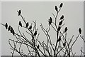
21 waxwings near Matalan
These waxwings, part of a flock of more than thirty, were gathered on a single tree in Easlea Road, on St Edmundsbury Retail Park.
Image: © Bob Jones
Taken: 5 Mar 2011
0.12 miles
2
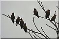
Seven waxwing silhouettes
These waxwings, part of a flock of more than thirty, were gathered on a single tree in Easlea Road, on St Edmundsbury Retail Park.
Image: © Bob Jones
Taken: 5 Mar 2011
0.12 miles
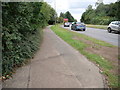
4
St. Edmundsbury Retail Park
Footpath/Cycleway to Easlea Road
Image: © John Myers
Taken: 23 Jun 2012
0.16 miles
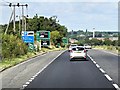
5
Looking along Orttewell Road from roundabout
Image: © David Pashley
Taken: 18 Aug 2020
0.20 miles
6
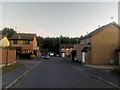
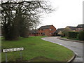
Wilbye Close, Bury St Edmunds
Wilbye Close is part of a large new residential area on the east side of Bury St. Edmunds.
Image: © Christopher Hilton
Taken: 18 Sep 2019
0.21 miles
7
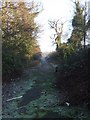
Footpath
Footpath running from Morton Hall Industrial Estate to the A14 this view looking north near to Blackthorpe, Suffolk.
Image: © Keith Evans
Taken: 14 Jan 2009
0.21 miles
9
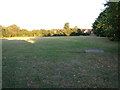
Recreation ground off Heldhaw Road
Also used as a football field in winter.
Image: © John Goldsmith
Taken: 21 Jul 2010
0.22 miles
10
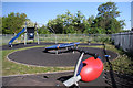
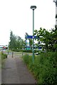
Play area in Moreton Hall Estate
This small children's play area is situated in the corner of the recreation ground at the junction of Symonds Road and Heldhaw Road, on the Moreton Hall Estate, Bury St Edmunds.
Image: © Bob Jones
Taken: 21 May 2010
0.23 miles