IMAGES TAKEN NEAR TO
Compiegne Way, BURY ST. EDMUNDS, IP32 7BD
Introduction
This page details the photographs taken nearby to Compiegne Way, IP32 7BD by members of the Geograph project.
The Geograph project started in 2005 with the aim of publishing, organising and preserving representative images for every square kilometre of Great Britain, Ireland and the Isle of Man.

There are currently over 7.5m images from over14,400 individuals and you can help contribute to the project by visiting https://www.geograph.org.uk
Image Map
Images are licensed for reuse under creativecommons.org/licenses/by-sa/2.0
Notes
- Clicking on the map will re-center to the selected point.
- The higher the marker number, the further away the image location is from the centre of the postcode.
Image Listing (12 Images Found)
Images are licensed for reuse under creativecommons.org/licenses/by-sa/2.0
Image
Details
Distance
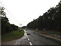
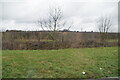
1
Field boundary at Westfield Farm
The trees mark the boundary of the garden of Westfield Farm.
Image: © Bob Jones
Taken: 2 Oct 2008
0.04 miles
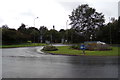
2

Countryside around Westfield Farm
Viewed from the car park of Abbotsgate House, Hollow Road.
Image: © John Goldsmith
Taken: 20 Oct 2008
0.06 miles
3
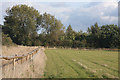
Paddock near Westfield Farm
This paddock lies south of the bridleway between Westfield Farm and Barton Stud.
Image: © Bob Jones
Taken: 2 Oct 2008
0.16 miles
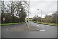
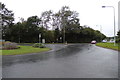
6
Hollow Road, Bury St. Edmunds
At the junction with the A143
Image: © Geographer
Taken: 15 Sep 2017
0.21 miles
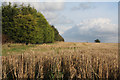
9
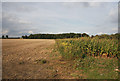
Stubble, sunflowers and maize
The edge of this field is planted with maize and sunflowers as cover for partridge.
Image: © Bob Jones
Taken: 2 Oct 2008
0.23 miles