
IMAGES TAKEN NEAR TO
Hollow Road, BURY ST. EDMUNDS, IP32 7AY
Introduction
This page details the photographs taken nearby to Hollow Road, IP32 7AY by members of the Geograph project.
The Geograph project started in 2005 with the aim of publishing, organising and preserving representative images for every square kilometre of Great Britain, Ireland and the Isle of Man.

There are currently over 7.5m images from over14,400 individuals and you can help contribute to the project by visiting https://www.geograph.org.uk
Image Map
Images are licensed for reuse under creativecommons.org/licenses/by-sa/2.0
Notes
- Clicking on the map will re-center to the selected point.
- The higher the marker number, the further away the image location is from the centre of the postcode.
Image Listing (22 Images Found)
Images are licensed for reuse under creativecommons.org/licenses/by-sa/2.0
Image
Details
Distance
1
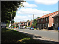
Houses in Hollow Road, Bury St Edmunds
Image: © Evelyn Simak
Taken: 31 Aug 2010
0.05 miles
3
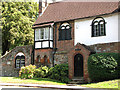
St Nicholas' House, Bury St Edmunds
This old house is situated in Hollow Road and adjoins the ruins of St Nicholas' hospital. For a full view see > http://www.geograph.org.uk/photo/2044082.
Image: © Evelyn Simak
Taken: 31 Aug 2010
0.08 miles
4
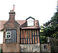
St Nicholas' House, Bury St Edmunds (detail)
This old house is situated in Hollow Road and adjoins the ruins of St Nicholas' hospital. For a full view see > http://www.geograph.org.uk/photo/2044082.
Image: © Evelyn Simak
Taken: 31 Aug 2010
0.08 miles
5
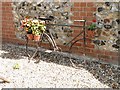
Flower seller's bike?
I don't think so, but it does make an attractive way of showing flowers.
Image: © Adrian S Pye
Taken: 31 Aug 2010
0.09 miles
6
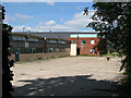
Industrial units west of Hollow Road, Bury St Edmunds
Image: © Evelyn Simak
Taken: 31 Aug 2010
0.09 miles
7
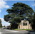
The ruined St Nicholas' hospital, Bury St Edmunds
It is adjoined by St Nicholas' House > http://www.geograph.org.uk/photo/2044082. The south wall with a window that is believed to have come from St Petronilla's church sits in the fork formed by Hollow Road (at left) and Barton Road.
Founded by an unknown abbot of Bury St Edmunds, the hospital of St. Nicholas was situated just outside the east gate. It consisted of a master, a chaplain, and several brethren. The earliest known dated reference to it is of the year 1224, when Henry III granted a fair to the master of the hospital of St. Nicholas, to be held on the feast and vigil of the Translation of St. Nicholas.
Image: © Evelyn Simak
Taken: 31 Aug 2010
0.10 miles
8
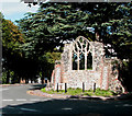
The ruined St Nicholas' hospital, Bury St Edmunds
It is adjoined by St Nicholas' House > http://www.geograph.org.uk/photo/2044082. The south wall with a window that is believed to have come from St Petronilla's church sits in the fork formed by Hollow Road (at right) and Barton Road.
Founded by an unknown abbot of Bury St Edmunds, the hospital of St. Nicholas was situated just outside the east gate. It consisted of a master, a chaplain, and several brethren. The earliest known dated reference to it is of the year 1224, when Henry III granted a fair to the master of the hospital of St. Nicholas, to be held on the feast and vigil of the Translation of St. Nicholas.
Image: © Evelyn Simak
Taken: 31 Aug 2010
0.10 miles
9
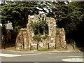
Part of the Hospital of St. Nicholas
These ruins belong to the Hospital of St. Nicholas, one of five hospitals that once stood in Bury during the time before the abbey was destroyed. The actual window in this ruin, is said to have originally come from the former Leper Hospital of St. Petronilla.
Image: © Robert Edwards
Taken: 15 Aug 2007
0.10 miles
10
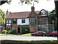
St Nicholas' House, Bury St Edmunds
This old house is situated in Hollow Road and adjoins the ruins of St Nicholas' hospital > http://www.geograph.org.uk/photo/2044091.
Image: © Evelyn Simak
Taken: 31 Aug 2010
0.10 miles