IMAGES TAKEN NEAR TO
Purdys Close, IP32 6GQ
Introduction
This page details the photographs taken nearby to Purdys Close, IP32 6GQ by members of the Geograph project.
The Geograph project started in 2005 with the aim of publishing, organising and preserving representative images for every square kilometre of Great Britain, Ireland and the Isle of Man.

There are currently over 7.5m images from over14,400 individuals and you can help contribute to the project by visiting https://www.geograph.org.uk
Image Map
Images are licensed for reuse under creativecommons.org/licenses/by-sa/2.0
Notes
- Clicking on the map will re-center to the selected point.
- The higher the marker number, the further away the image location is from the centre of the postcode.
Image Listing (5 Images Found)
Images are licensed for reuse under creativecommons.org/licenses/by-sa/2.0
Image
Details
Distance
1
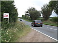
Westley Road
Looking south west along Westley Road that runs between the village of Fornham All Saints and the A.14 near to Bury St.Edmunds, Suffolk.
Image: © Keith Evans
Taken: 18 Aug 2011
0.08 miles
2
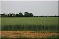
Field west of Bury St Edmunds
One of Suffolk's many huge fields. The shiny new tower of Bury St Edmunds Cathedral can be seen in the far distance, right.
Image: © Bob Jones
Taken: 23 Jun 2005
0.11 miles
3
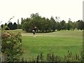
Golfer
Golfer at the Bury St.Edmunds Golf Club Bury St.Edmunds, Suffolk.
Image: © Keith Evans
Taken: 18 Aug 2011
0.14 miles
4
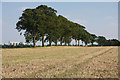
Line of trees
Viewed from the footpath which follows the B1106 Westley Road, the silos of the sugar beet factory can be seen to the left of the trees.
Image: © Bob Jones
Taken: 19 Sep 2008
0.21 miles
5
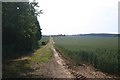
Track leading to Hyde Wood
The track leads off the B1106 behind the former school.
Image: © Bob Jones
Taken: 22 Jun 2005
0.22 miles