IMAGES TAKEN NEAR TO
Mildenhall Road, BURY ST. EDMUNDS, IP32 6EH
Introduction
This page details the photographs taken nearby to Mildenhall Road, IP32 6EH by members of the Geograph project.
The Geograph project started in 2005 with the aim of publishing, organising and preserving representative images for every square kilometre of Great Britain, Ireland and the Isle of Man.

There are currently over 7.5m images from over14,400 individuals and you can help contribute to the project by visiting https://www.geograph.org.uk
Image Map
Images are licensed for reuse under creativecommons.org/licenses/by-sa/2.0
Notes
- Clicking on the map will re-center to the selected point.
- The higher the marker number, the further away the image location is from the centre of the postcode.
Image Listing (42 Images Found)
Images are licensed for reuse under creativecommons.org/licenses/by-sa/2.0
Image
Details
Distance
4
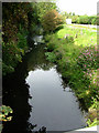
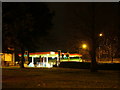
River Lark north of Tollgate Bridge
The view in the opposite direction to Image
Image: © John Goldsmith
Taken: 21 Aug 2011
0.10 miles
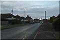
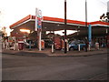
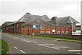
5
Tollgate Garage, Bury St. Edmunds
Seen across the large roundabout with the traffic light junction on the corner
Image: © John Goldsmith
Taken: 10 Dec 2008
0.12 miles
10
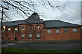
Mildenhall Maltings, Mildenhall Road, Bury St Edmunds, Suffolk
Image: © Oast House Archive
Taken: 15 Aug 2009
0.13 miles