IMAGES TAKEN NEAR TO
Hanover Close, BURY ST. EDMUNDS, IP32 6BT
Introduction
This page details the photographs taken nearby to Hanover Close, IP32 6BT by members of the Geograph project.
The Geograph project started in 2005 with the aim of publishing, organising and preserving representative images for every square kilometre of Great Britain, Ireland and the Isle of Man.

There are currently over 7.5m images from over14,400 individuals and you can help contribute to the project by visiting https://www.geograph.org.uk
Image Map
Images are licensed for reuse under creativecommons.org/licenses/by-sa/2.0
Notes
- Clicking on the map will re-center to the selected point.
- The higher the marker number, the further away the image location is from the centre of the postcode.
Image Listing (52 Images Found)
Images are licensed for reuse under creativecommons.org/licenses/by-sa/2.0
Image
Details
Distance
1
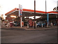
Tollgate Garage, Bury St. Edmunds
Seen across the large roundabout with the traffic light junction on the corner
Image: © John Goldsmith
Taken: 10 Dec 2008
0.04 miles
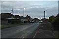
3
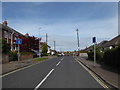
Looking from Norman Road into Philip Road
Image: © Basher Eyre
Taken: 16 Sep 2018
0.06 miles
4
Dirt track off Fornham Road, Bury St. Edmunds
The other end of the track seen in Image Like many of the tracks this one houses lots of garages, but unusually this one has a classy wall along one side.
Image: © John Goldsmith
Taken: 6 Sep 2009
0.08 miles
6
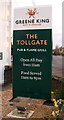
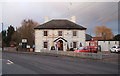
Sign for the Tollgate public House, Bury St Edmunds
Image: © JThomas
Taken: 5 Mar 2016
0.09 miles
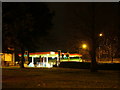
8
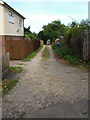
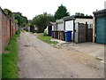
Unmade road in housing estate, northern Bury St. Edmunds
The monks of the abbey defined a rectangular street plan for the mediaeval parts of Bury St. Edmunds. Centuries later when the town expanded north of the newly built railway tracks a rectangular plan was again adopted, but some of the roads were left as dirt tracks. Some are little used and overgrown but this one is quite clear - indeed you can see the cars and houses in Fornham Road at the far end in this shot. Does the existence of the bins here imply that the refuse truck passes down the track?
Image: © John Goldsmith
Taken: 6 Sep 2009
0.09 miles
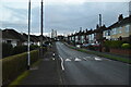
9
Looking from Tollgate Lane into Philip Road
Image: © Basher Eyre
Taken: 16 Sep 2018
0.10 miles