IMAGES TAKEN NEAR TO
Meadow Brown Way, BURY ST. EDMUNDS, IP31 3TU
Introduction
This page details the photographs taken nearby to Meadow Brown Way, IP31 3TU by members of the Geograph project.
The Geograph project started in 2005 with the aim of publishing, organising and preserving representative images for every square kilometre of Great Britain, Ireland and the Isle of Man.

There are currently over 7.5m images from over14,400 individuals and you can help contribute to the project by visiting https://www.geograph.org.uk
Image Map
Images are licensed for reuse under creativecommons.org/licenses/by-sa/2.0
Notes
- Clicking on the map will re-center to the selected point.
- The higher the marker number, the further away the image location is from the centre of the postcode.
Image Listing (15 Images Found)
Images are licensed for reuse under creativecommons.org/licenses/by-sa/2.0
Image
Details
Distance
5
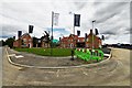
Thurston: Large housing development
Image: © Michael Garlick
Taken: 11 Jul 2020
0.14 miles
6
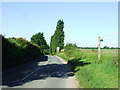
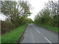
Road And Footpath
Road and footpath near to Thurston, Suffolk.
Image: © Keith Evans
Taken: 16 Jun 2009
0.16 miles
8
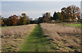
Footpath to Thurston Church
This well-used path leads diagonally across a field to Thurston Church, between Norton Road and Church Road.
Image: © Bob Jones
Taken: 19 Nov 2009
0.16 miles
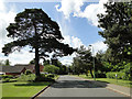
9
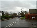
School Road, Thurston
Junction with St. Peters Way and School Lane
Image: © John Myers
Taken: 21 Dec 2016
0.20 miles
10

Thurston: Large housing development
Image: © Michael Garlick
Taken: 26 Jun 2020
0.21 miles