IMAGES TAKEN NEAR TO
Birch Road, BURY ST. EDMUNDS, IP31 3SA
Introduction
This page details the photographs taken nearby to Birch Road, IP31 3SA by members of the Geograph project.
The Geograph project started in 2005 with the aim of publishing, organising and preserving representative images for every square kilometre of Great Britain, Ireland and the Isle of Man.

There are currently over 7.5m images from over14,400 individuals and you can help contribute to the project by visiting https://www.geograph.org.uk
Image Map
Images are licensed for reuse under creativecommons.org/licenses/by-sa/2.0
Notes
- Clicking on the map will re-center to the selected point.
- The higher the marker number, the further away the image location is from the centre of the postcode.
Image Listing (11 Images Found)
Images are licensed for reuse under creativecommons.org/licenses/by-sa/2.0
Image
Details
Distance
1
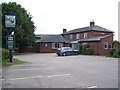
School Road, Thurston
Junction with St. Peters Way and School Lane
Image: © John Myers
Taken: 21 Dec 2016
0.10 miles
2
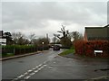
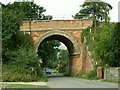
Bridge over the railway
Thedwastre Road narrows to cross the railway and enter the main part of the village of Thurston.
Image: © Andrew Hill
Taken: 1 May 2009
0.18 miles
4
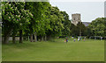
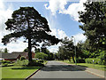
Cricket ground and recreational area
A true village cricket ground with a view of the church, lined on two sides with trees, mainly horse chestnuts.
Image: © Andrew Hill
Taken: 1 May 2009
0.20 miles
5
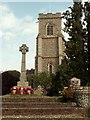
St. Peter's church and War Memorial, Thurston, Suffolk
Most of this church was rebuilt in 1861-2 by E. C. Hakewill, after the tower of the original church fell and destroyed other parts of the church.
Image: © Robert Edwards
Taken: 16 Aug 2006
0.21 miles
6

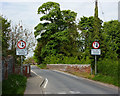
Park in Thurston
A neat and attractive area. On the left is a National Cycle Network millennium sign.
Image: © Andrew Hill
Taken: 29 Apr 2009
0.22 miles
8
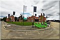
Thurston: Large housing development
Image: © Michael Garlick
Taken: 11 Jul 2020
0.24 miles
9
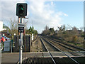
View East from Thurston Railway Station
The line runs straight for many miles (also see photo West from station). This direction leads to Stowmarket and Ipswich. As the line is on a high embankment the station is unusual, with the rail line at the first storey.
Image: © John Goldsmith
Taken: 13 Dec 2007
0.25 miles