IMAGES TAKEN NEAR TO
The Gardens, BURY ST. EDMUNDS, IP31 3LB
Introduction
This page details the photographs taken nearby to The Gardens, IP31 3LB by members of the Geograph project.
The Geograph project started in 2005 with the aim of publishing, organising and preserving representative images for every square kilometre of Great Britain, Ireland and the Isle of Man.

There are currently over 7.5m images from over14,400 individuals and you can help contribute to the project by visiting https://www.geograph.org.uk
Image Map
Images are licensed for reuse under creativecommons.org/licenses/by-sa/2.0
Notes
- Clicking on the map will re-center to the selected point.
- The higher the marker number, the further away the image location is from the centre of the postcode.
Image Listing (31 Images Found)
Images are licensed for reuse under creativecommons.org/licenses/by-sa/2.0
Image
Details
Distance
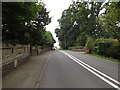
1
A1088 Ixworth Road, Stanton Street
At the junction with Hall's Lane
Image: © Geographer
Taken: 29 Aug 2016
0.09 miles
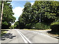
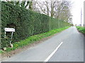
2
Halls Lane, Stanton Street
At the junction with the A1088 Ixworth Road
Image: © Geographer
Taken: 29 Aug 2016
0.09 miles
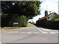
3
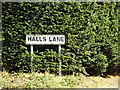
Halls Lane sign
On Hall's Lane at the junction with the A1088 Ixworth Road
Image: © Geographer
Taken: 29 Aug 2016
0.10 miles
4
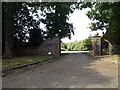
Entrance to Little Haugh Hall
Off the A1088 Ixworth Road
Image: © Geographer
Taken: 29 Aug 2016
0.10 miles
5
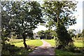
Track to Little Haugh Farm
This farm is attached to Little Haugh Hall, Norton.
Image: © Bob Jones
Taken: 19 Sep 2006
0.10 miles
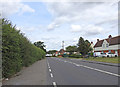
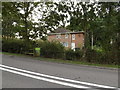
7
Houses along Ixworth Road, the A1088
Image: © Robert Edwards
Taken: 17 Mar 2011
0.12 miles
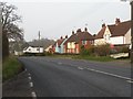
9
The Lodge, Stanton street
Off the A1088 Ixworth Road
Image: © Geographer
Taken: 19 Sep 2016
0.13 miles