IMAGES TAKEN NEAR TO
Elmswell Road, BURY ST. EDMUNDS, IP31 3HQ
Introduction
This page details the photographs taken nearby to Elmswell Road, IP31 3HQ by members of the Geograph project.
The Geograph project started in 2005 with the aim of publishing, organising and preserving representative images for every square kilometre of Great Britain, Ireland and the Isle of Man.

There are currently over 7.5m images from over14,400 individuals and you can help contribute to the project by visiting https://www.geograph.org.uk
Image Map
Images are licensed for reuse under creativecommons.org/licenses/by-sa/2.0
Notes
- Clicking on the map will re-center to the selected point.
- The higher the marker number, the further away the image location is from the centre of the postcode.
Image Listing (39 Images Found)
Images are licensed for reuse under creativecommons.org/licenses/by-sa/2.0
Image
Details
Distance
1
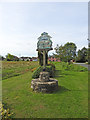
Great Ashfield village sign
The sign is double sided.
Close look of this face https://www.geograph.org.uk/photo/6218249
South face https://www.geograph.org.uk/photo/6218253
Image: © Adrian S Pye
Taken: 21 Jul 2019
0.10 miles
2
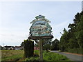
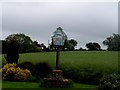
Great Ashfield village sign (detail) north face
Great Ashfield is two sided sign and is surmounted on this side by a shield bearing the pierced crown of St Edmund supported by leaves. Below the name is the unmistakable image of a B17 Fortress of the 385 Bomb Group which flew from the airfield here during World War Two. Immediately below the aircraft is the Lord Thurlow village hall. In the foreground is a man with horse drawn plough, and a cock pheasant, representing the agricultural heritage of the parish.
The other side https://www.geograph.org.uk/photo/6218253 is surmounted by a shield with the emblem of the 385th Bombardment Group bearing the motto “Ales Victoria” (Winged Victory). Below the name is the unmistakable image of a B17 Fortress of the 385 Bomb Group bearing the ‘square G’ tail marking flying over the parish church of All Saints. The Saxon Cross, on the right, it stands in the grounds of Great Ashfield House. Prior to it being moved there in 1786 it served as a footbridge across the small stream leading to All Saints Church. Its origin dates from the 9th to the 12th century. On the left is a wheatsheaf and wild flowers which illustrate in some way, the agricultural and natural environment of the parish.
Image: © Adrian S Pye
Taken: 21 Jul 2019
0.10 miles
3
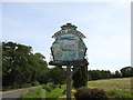
Great Ashfield village sign, (detail) south face
This side is surmounted by a shield bearing the emblem of the 385th Bombardment Group bearing the motto “Ales Victoria” (Winged Victory). Below the name is the unmistakable image of a B17 Fortress of the 385 Bomb Group bearing the ‘square G’ tail marking flying over the parish church of All Saints. The Saxon Cross, on the right, it stands in the grounds of Great Ashfield House. Prior to it being moved there in 1786 it served as a footbridge across the small stream leading to All Saints Church. Its origin dates from the 9th to the 12th century. On the left is a wheatsheaf and wild flowers which illustrate in some way, the agricultural and natural environment of the parish.
The other side https://www.geograph.org.uk/photo/6218249 is surmounted by a shield bearing the pierced crown of St Edmund supported by leaves. Below the name is the unmistakable image of a B17 Fortress of the 385 Bomb Group which flew from the airfield here during World War Two. Immediately below the aircraft is the Lord Thurlow village hall. In the foreground is a man with horse drawn plough, and a cock pheasant, representing the agricultural heritage of the parish.
Image: © Adrian S Pye
Taken: 21 Jul 2019
0.10 miles
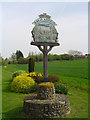
5
Great Ashfield, Village sign
The sign depicts All Saints Church, A B-17 bomber from WW2 and the Saxon cross. The village is close to RAF Great Ashfield which was home to USAAF 8th Air Force 385th Bombardment Group from 1943 to 1945. This represents just 2 years in the 1000 years plus history of the village. The village is listed in the Domesday Book as having 67 inhabitants. The Saxon cross is now located in the next grid square http://www.geograph.org.uk/photo/13602 having been found in the church yard in 1786 where it had been used as a footbridge across a stream.
Image: © Bikeboy
Taken: 29 May 2014
0.14 miles
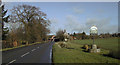
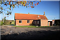
7
The old school at Ashfield is the village hall
An exhibition about the WW1 airfield is in progress.
A memorial on the old airfield (which is private land) has recently been erected.
Great Ashfield airfield was otherwise known as RAF Elmswell.
From 1942 it was a U.S.A.A.F. airbase for 385th BG (H) until the end of the war. After the war, the airfield reverted to RAF control and it came under Maintenance Command as a sub-site for bomb storage before being finally abandoned and sold in 1955.
Image: © Adrian S Pye
Taken: 21 Jul 2019
0.17 miles
8
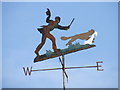
Chasing The Fox
Weather vane great Ashfield, Suffolk.
Image: © Keith Evans
Taken: 27 Sep 2009
0.18 miles
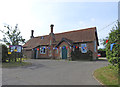
9
Great Ashfield village hall
This former primary school is now the village hall for Great Ashfield. A modern extension has been added to the rear of the original building.
Image: © Bob Jones
Taken: 12 Nov 2009
0.19 miles
10
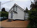
White board building, Great Ashfield
It looks as though it may have been a chapel originally.
Image: © Bikeboy
Taken: 29 May 2014
0.19 miles