IMAGES TAKEN NEAR TO
Thomas Close, BURY ST. EDMUNDS, IP31 2UQ
Introduction
This page details the photographs taken nearby to Thomas Close, IP31 2UQ by members of the Geograph project.
The Geograph project started in 2005 with the aim of publishing, organising and preserving representative images for every square kilometre of Great Britain, Ireland and the Isle of Man.

There are currently over 7.5m images from over14,400 individuals and you can help contribute to the project by visiting https://www.geograph.org.uk
Image Map
Images are licensed for reuse under creativecommons.org/licenses/by-sa/2.0
Notes
- Clicking on the map will re-center to the selected point.
- The higher the marker number, the further away the image location is from the centre of the postcode.
Image Listing (100 Images Found)
Images are licensed for reuse under creativecommons.org/licenses/by-sa/2.0
Image
Details
Distance
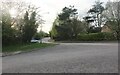
2
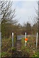
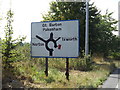
Crown Lane crossing the A143
Footpath into Ixworth
Image: © John Myers
Taken: 11 Mar 2016
0.10 miles
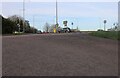
3
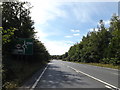
A143 Bury Road & roadsign
Approaching the junction with the A1088 Stow Lane & Stow Road
Image: © Geographer
Taken: 29 Aug 2016
0.12 miles
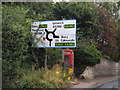
4
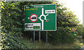
Roadsign on the A143 Bury Road
Approaching the junction with the A1088 Stow Lane & Stow Road
Image: © Geographer
Taken: 29 Aug 2015
0.13 miles
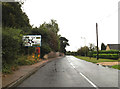
5
Roadsign on the A143 Bury Road
Approaching the junction with the A1088 Stow Lane & Stow Road
Image: © Geographer
Taken: 29 Aug 2016
0.15 miles
10

Stow Road, Ixworth
At the junction with the A143 Bury Road & A1088 Stow Lane
Image: © Geographer
Taken: 16 Sep 2016
0.17 miles