IMAGES TAKEN NEAR TO
School Road, BURY ST. EDMUNDS, IP31 2RJ
Introduction
This page details the photographs taken nearby to School Road, IP31 2RJ by members of the Geograph project.
The Geograph project started in 2005 with the aim of publishing, organising and preserving representative images for every square kilometre of Great Britain, Ireland and the Isle of Man.

There are currently over 7.5m images from over14,400 individuals and you can help contribute to the project by visiting https://www.geograph.org.uk
Image Map
Images are licensed for reuse under creativecommons.org/licenses/by-sa/2.0
Notes
- Clicking on the map will re-center to the selected point.
- The higher the marker number, the further away the image location is from the centre of the postcode.
Image Listing (40 Images Found)
Images are licensed for reuse under creativecommons.org/licenses/by-sa/2.0
Image
Details
Distance
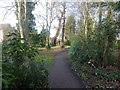
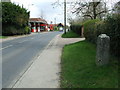
2
B1106 Mill Road, Great Barton
At the junction with School Road
Image: © Geographer
Taken: 16 Sep 2016
0.16 miles
3
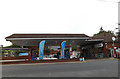
Hursts Esso Fuel Filling Station & Store
Off the A143 The Street at the junction with Elms Close
Image: © Geographer
Taken: 19 Sep 2016
0.18 miles
4
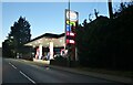
Petrol station on The Street, Great Barton
Image: © David Howard
Taken: 2 Oct 2022
0.18 miles
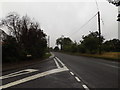
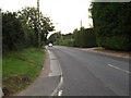
5
Old Milepost
Old milepost on the A.143 at Great Barton, Suffolk. For close up view see http://www.geograph.org.uk/photo/1240564 and for more info on the post see http://milestones.megalithia.com/sites/tl892672.htm do have a look at their home page.
Image: © Keith Evans
Taken: 7 Apr 2009
0.18 miles
6
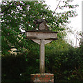
Great Barton village sign
The inspiration for the village sign was the painting of “The Gleaners” by French painter Jean-François Millet (1814-1875) which depicts three women stooping in the fields to glean the leftovers from the harvest. (Great Barton Website).
For a more recent, repainted version see https://www.geograph.org.uk/photo/6767944
Image: © Adrian S Pye
Taken: 22 Apr 2007
0.18 miles
7
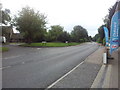
The Street through Great Barton, looking south-west
Image: © Helen Steed
Taken: 14 Sep 2013
0.18 miles
8

A143 The Street, Great Barton
At the junction with Elms Close
Image: © Geographer
Taken: 19 Sep 2016
0.19 miles
9
A143 The Street, Great Barton
At the junction with Elms Close
Image: © Geographer
Taken: 19 Sep 2016
0.19 miles
10
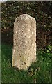
Old Milestone by the A143, The Street, Great Barton
Carved stone post by the A143, in parish of GREAT BARTON (ST EDMUNDSBURY District), East of The Forge, The Street, on verge, back to high cut hedge, on South East side of road. Erected by the Scole Bridge to Bury St Edmunds turnpike trust in the 19th century.
Inscription reads:-
: (Bury St Edmunds / 3) : : (Scole / 19)
Carved benchmark on South East face
Grade II listed.
List Entry Number: 1194744 https://historicengland.org.uk/listing/the-list/list-entry/1194744
Milestone Society National ID: SU_BUSC03.
Image: © M Benford
Taken: 23 Mar 2012
0.19 miles