IMAGES TAKEN NEAR TO
East Barton, Great Barton, BURY ST. EDMUNDS, IP31 2QX
Introduction
This page details the photographs taken nearby to IP31 2QX by members of the Geograph project.
The Geograph project started in 2005 with the aim of publishing, organising and preserving representative images for every square kilometre of Great Britain, Ireland and the Isle of Man.

There are currently over 7.5m images from over14,400 individuals and you can help contribute to the project by visiting https://www.geograph.org.uk
Image Map
Images are licensed for reuse under creativecommons.org/licenses/by-sa/2.0
Notes
- Clicking on the map will re-center to the selected point.
- The higher the marker number, the further away the image location is from the centre of the postcode.
Image Listing (11 Images Found)
Images are licensed for reuse under creativecommons.org/licenses/by-sa/2.0
Image
Details
Distance
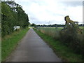
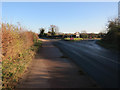
2
National cycle route 51
Between Bury St. Edmunds and Thurston.
Image: © Hugh Venables
Taken: 22 Dec 2016
0.06 miles
4

Rougham Airfield
Rougham Airfield bounded by National Cycle Route 51.
Image: © Greg Aspland
Taken: 18 Oct 2008
0.09 miles
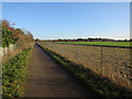
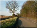
5

National Cycle Route 51 at Battlies Green
This off-road section of NCR51 follows the northern boundary of the former Rougham Airfield.
Image: © Bob Jones
Taken: 18 Jun 2009
0.13 miles
6
National Cycle Route
Part of the national cycle route number 51 near to Blackthorpe, Suffolk.
Image: © Keith Evans
Taken: 31 Aug 2009
0.17 miles
7
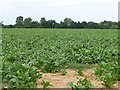
Looking towards the windsock, Rougham Airfield
Looking north-east across a sugar beet field, from Rougham Control Tower Museum.
Image: © Christine Johnstone
Taken: 9 Aug 2015
0.18 miles
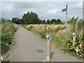
8
National cycle route 51
Briefly by the road for the junction, before going back behind the hedge
Image: © Hugh Venables
Taken: 22 Dec 2016
0.19 miles
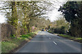
10
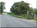
Footpath And Road
Footpath and road Battlies Green near to Blackthorpe, Suffolk.
Image: © Keith Evans
Taken: 31 Aug 2009
0.22 miles