IMAGES TAKEN NEAR TO
High Street, BURY ST. EDMUNDS, IP31 2HT
Introduction
This page details the photographs taken nearby to High Street, IP31 2HT by members of the Geograph project.
The Geograph project started in 2005 with the aim of publishing, organising and preserving representative images for every square kilometre of Great Britain, Ireland and the Isle of Man.

There are currently over 7.5m images from over14,400 individuals and you can help contribute to the project by visiting https://www.geograph.org.uk
Image Map
Images are licensed for reuse under creativecommons.org/licenses/by-sa/2.0
Notes
- Clicking on the map will re-center to the selected point.
- The higher the marker number, the further away the image location is from the centre of the postcode.
Image Listing (238 Images Found)
Images are licensed for reuse under creativecommons.org/licenses/by-sa/2.0
Image
Details
Distance
1
![Ixworth houses [9]](https://s0.geograph.org.uk/geophotos/06/70/58/6705856_eef9558a_120x120.jpg)
Ixworth houses [9]
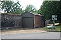
Known as Trayton House until 1958, Cyder House in High Street is a 15th century open hall house with an upper floor inserted in the 16th century. Timber framed encased in 19th century white brick. The house and the buildings adjoining Image were the Ixworth Cyder Factory. Listed, grade II, with details at: https://historicengland.org.uk/listing/the-list/list-entry/1031478
Ixworth is a village some 7 miles north east of Bury St Edmunds. Settled in Roman times and the site of a Roman fort. Later a civilian settlement was established and it became an important junction in the Roman road system of East Anglia. An Augustinian priory was founded in about 1170 and dissolved in 1537. Ixworth is the site of the earliest rural council housing built in England. Now most working residents commute to Bury St Edmunds.
Image: © Michael Dibb
Taken: 7 Sep 2020
0.00 miles
2
![Ixworth buildings [1]](https://s1.geograph.org.uk/geophotos/06/70/58/6705873_225304bc_120x120.jpg)
Ixworth buildings [1]
Adjoining Cyder House Image this shop with office above and the low brick buildings beyond were the Ixworth Cyder Factory. Originally built in the early 16th century as a parlour wing to Cyder House the building is timber framed and jettied to the street with exposed timbers on the first floor. The shop front is late 19th century. Listed, grade II, with details at: https://historicengland.org.uk/listing/the-list/list-entry/1376841
Ixworth is a village some 7 miles north east of Bury St Edmunds. Settled in Roman times and the site of a Roman fort. Later a civilian settlement was established and it became an important junction in the Roman road system of East Anglia. An Augustinian priory was founded in about 1170 and dissolved in 1537. Ixworth is the site of the earliest rural council housing built in England. Now most working residents commute to Bury St Edmunds.
Image: © Michael Dibb
Taken: 7 Sep 2020
0.01 miles
3
Ixworth old fire station
Ixworth old fire station, at the junction of High Street & Stow Road, Ixworth, Suffolk
Image: © Kevin Hale
Taken: 29 Jun 2010
0.02 miles
4
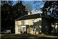
The Priory, Ixworth
Despite the name, Ixworth Abbey house incorporates the remains of the medieval Priory itself, rather than this house. The main front is early 19th century, although there are earlier parts to the rear. Listed Grade II.
Image: © Alan Murray-Rust
Taken: 17 Feb 2022
0.02 miles
5
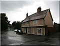
Holmlea, Ixworth
Sixteenth century house https://historicengland.org.uk/listing/the-list/list-entry/1376824
Image: © Jonathan Thacker
Taken: 3 Aug 2021
0.02 miles
6
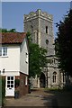
Ixworth Church
St Mary's church lies just west of the High Street in this large and busy village, now thankfully by-passed.
Image: © Bob Jones
Taken: 26 Jul 2006
0.03 miles
7
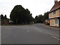
High Street, Ixworth
At the junction with Stow Road & Bury Road
Image: © Geographer
Taken: 19 Sep 2016
0.03 miles
8
![Ixworth houses [45]](https://s0.geograph.org.uk/geophotos/06/70/88/6708808_c476676a_120x120.jpg)
Ixworth houses [45]
This fine former farmhouse, Dover House, is a Wealden type, with cross wing ends jettied on the street frontage only. Built in the 15th century, timber framed, stuccoed and pargetted on the front. There are some fine medieval and 16th century internal features. The garden wall to the right which connects to Cyder House Image is included in the listing. Listed, grade II*, with details at: https://historicengland.org.uk/listing/the-list/list-entry/1031458
Ixworth is a village some 7 miles north east of Bury St Edmunds. Settled in Roman times and the site of a Roman fort. Later a civilian settlement was established and it became an important junction in the Roman road system of East Anglia. An Augustinian priory was founded in about 1170 and dissolved in 1537. Ixworth is the site of the earliest rural council housing built in England. Now most working residents commute to Bury St Edmunds.
Image: © Michael Dibb
Taken: 7 Sep 2020
0.03 miles
9
![Ixworth features [4]](https://s1.geograph.org.uk/geophotos/06/70/87/6708785_bf39864c_120x120.jpg)
Ixworth features [4]
The village sign stands on the corner of High Street and Stow Road.
Ixworth is a village some 7 miles north east of Bury St Edmunds. Settled in Roman times and the site of a Roman fort. Later a civilian settlement was established and it became an important junction in the Roman road system of East Anglia. An Augustinian priory was founded in about 1170 and dissolved in 1537. Ixworth is the site of the earliest rural council housing built in England. Now most working residents commute to Bury St Edmunds.
Image: © Michael Dibb
Taken: 7 Sep 2020
0.03 miles
10
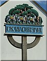
Ixworth village sign
The packhorses and guide are indicative of the village's location on the old Peddars Way.
Image: © Alan Murray-Rust
Taken: 17 Feb 2022
0.03 miles