IMAGES TAKEN NEAR TO
Glassfield Road, BURY ST. EDMUNDS, IP31 2DS
Introduction
This page details the photographs taken nearby to Glassfield Road, IP31 2DS by members of the Geograph project.
The Geograph project started in 2005 with the aim of publishing, organising and preserving representative images for every square kilometre of Great Britain, Ireland and the Isle of Man.

There are currently over 7.5m images from over14,400 individuals and you can help contribute to the project by visiting https://www.geograph.org.uk
Image Map
Images are licensed for reuse under creativecommons.org/licenses/by-sa/2.0
Notes
- Clicking on the map will re-center to the selected point.
- The higher the marker number, the further away the image location is from the centre of the postcode.
Image Listing (34 Images Found)
Images are licensed for reuse under creativecommons.org/licenses/by-sa/2.0
Image
Details
Distance
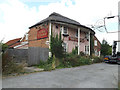
1
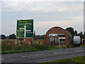
Empty Shell
Almost gone is this roofless arched building at the corner of the A143 and an unclassified road heading towards Bardwell.
Image: © Ian Paterson
Taken: 22 Sep 2008
0.10 miles
2
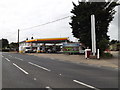
Shell Fuel Filling Station, Stanton
Off the A143 Bury Road
Image: © Geographer
Taken: 16 Aug 2016
0.11 miles
3
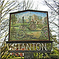
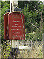
Stanton village sign
The sign depicts a traction/threshing engine, representing the many engineers of the village in the past. The Upthorpe Mill and the roofless church of St John the Baptist are in the background. In the foreground is a hay cutter. https://www.geograph.org.uk/photo/6744671
Image: © Adrian S Pye
Taken: 2 Feb 2021
0.17 miles
4
Stanton village sign
The sign depicts a traction/threshing engine, representing the many engineers of the village in the past. The Upthorpe Mill and the roofless church of St John the Baptist are in the background. In the foreground is a hay cutter.
https://www.geograph.org.uk/photo/6744670
Image: © Adrian S Pye
Taken: 2 Feb 2021
0.18 miles
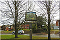
5
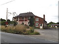
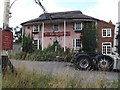
The Rose & Crown Public House, Stanton
Off the A143 Bury Road
Image: © Geographer
Taken: 16 Aug 2016
0.18 miles
6
The Rose & Crown Public House sign
Off the A143 Bury Road
Image: © Geographer
Taken: 16 Aug 2016
0.18 miles
7
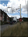
The Rose & Crown Public House sign
Off the A143 Bury Road
Image: © Geographer
Taken: 6 Aug 2016
0.18 miles
8
The Rose & Crown Public House, Stanton
Off the A143 Bury Road
Image: © Geographer
Taken: 6 Aug 2016
0.18 miles
9
The Rose & Crown Public House, Stanton
Off the A143 Bury Road
Image: © Geographer
Taken: 6 Aug 2016
0.18 miles
10
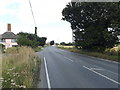
A143 Bury Road, Stanton
Near The Rose & Crown Public House
Image: © Geographer
Taken: 6 Aug 2016
0.19 miles