IMAGES TAKEN NEAR TO
St. Edmunds Square, BURY ST. EDMUNDS, IP31 1LT
Introduction
This page details the photographs taken nearby to St. Edmunds Square, IP31 1LT by members of the Geograph project.
The Geograph project started in 2005 with the aim of publishing, organising and preserving representative images for every square kilometre of Great Britain, Ireland and the Isle of Man.

There are currently over 7.5m images from over14,400 individuals and you can help contribute to the project by visiting https://www.geograph.org.uk
Image Map
Images are licensed for reuse under creativecommons.org/licenses/by-sa/2.0
Notes
- Clicking on the map will re-center to the selected point.
- The higher the marker number, the further away the image location is from the centre of the postcode.
Image Listing (2 Images Found)
Images are licensed for reuse under creativecommons.org/licenses/by-sa/2.0
Image
Details
Distance
1
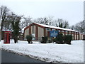
Chapel
Chapel at R.A.F. Honington, Suffolk.
Image: © Keith Evans
Taken: 10 Jan 2010
0.13 miles
2
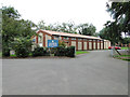
St Edmund's church, Honington
The church was built especially for the use of servicemen and women based at RAF Honington.
Image: © Adrian S Pye
Taken: 7 Sep 2014
0.13 miles