IMAGES TAKEN NEAR TO
Lingwood Close, BURY ST. EDMUNDS, IP31 1FB

Introduction

This page details the photographs taken nearby to Lingwood Close, IP31 1FB by members of the Geograph project.

The Geograph project started in 2005 with the aim of publishing, organising and preserving representative images for every square kilometre of Great Britain, Ireland and the Isle of Man.

There are currently over 7.5m images from over14,400 individuals and you can help contribute to the project by visiting https://www.geograph.org.uk

Image Map


Images are licensed for reuse under creativecommons.org/licenses/by-sa/2.0
Notes
  • Clicking on the map will re-center to the selected point.
  • The higher the marker number, the further away the image location is from the centre of the postcode.

Image Listing (75 Images Found)

Images are licensed for reuse under creativecommons.org/licenses/by-sa/2.0
  • ...
Image
Details
Distance
1
New housing development in Barningham
One year on from http://www.geograph.org.uk/photo/3971132
Image: © Adrian S Pye Taken: 8 May 2015
0.02 miles
2
New housing development in Barningham
Image: © Adrian S Pye Taken: 8 May 2015
0.02 miles
3
House building in Barningham
Image: © Bikeboy Taken: 4 May 2014
0.02 miles
4
Fison's old mill, Barningham
The mill which is featured on the village sign https://www.geograph.org.uk/photo/6741524 has been converted to residential.
Image: © Adrian S Pye Taken: 2 Feb 2021
0.11 miles
5
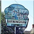
Barningham village sign
In the background of the sign is the flour mill with a man loading sacks onto his cart. The mill was built in 1826 in what had been maltings. The church of St Andrew is on the extreme left. A wheatsheaf reflects the farming tradition still carried on in the parish. The lady handing a coin to the children is the widow Morley, the first female appointed as overseer of the poor. https://www.geograph.org.uk/photo/4291007
Image: © Adrian S Pye Taken: 15 Apr 2007
0.13 miles
6
Barningham village sign
In the background of the sign is the flour mill with a man loading sacks onto his cart. The mill was built in 1826 in what had been maltings. The church of St Andrew is on the extreme left. The lady with the children is the widow Morley, the first female appointed as overseer of the poor. https://www.geograph.org.uk/photo/6741524
Image: © Adrian S Pye Taken: 15 Apr 2007
0.13 miles
7
Hopton Road, Barningham
Image: © David Howard Taken: 2 Oct 2022
0.15 miles
8
Looking across a field to Barningham
The tower of St. Andrew's church can be seen in the distance.
Image: © Robert Edwards Taken: 27 Jun 2012
0.16 miles
9
Mill Road, Barningham
Image: © Alex McGregor Taken: 24 Feb 2011
0.19 miles
10
Mill Road, Barningham
Image: © David Howard Taken: 2 Oct 2022
0.20 miles
  • ...