IMAGES TAKEN NEAR TO
Bardwell, BURY ST. EDMUNDS, IP31 1AY
Introduction
This page details the photographs taken nearby to IP31 1AY by members of the Geograph project.
The Geograph project started in 2005 with the aim of publishing, organising and preserving representative images for every square kilometre of Great Britain, Ireland and the Isle of Man.

There are currently over 7.5m images from over14,400 individuals and you can help contribute to the project by visiting https://www.geograph.org.uk
Image Map
Images are licensed for reuse under creativecommons.org/licenses/by-sa/2.0
Notes
- Clicking on the map will re-center to the selected point.
- The higher the marker number, the further away the image location is from the centre of the postcode.
Image Listing (13 Images Found)
Images are licensed for reuse under creativecommons.org/licenses/by-sa/2.0
Image
Details
Distance
1
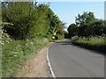
Spring Road, approaching Bardwell village
Image: © Robert Edwards
Taken: 3 May 2011
0.04 miles
2
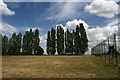
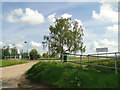
Bardwell recreation ground
This recreational area is located to the east of Spring Lane, Bardwell.
Image: © Bob Jones
Taken: 31 Jul 2006
0.11 miles
4
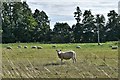
Bardwell: Large field with grazing sheep
Image: © Michael Garlick
Taken: 5 Sep 2020
0.12 miles
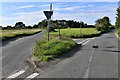
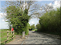
7
Y Junction
Road junction near to Bardwell, Suffolk.
Image: © Keith Evans
Taken: 6 Feb 2011
0.16 miles
8
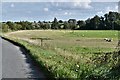
Bardwell: Large field with grazing sheep
Image: © Michael Garlick
Taken: 5 Sep 2020
0.17 miles
9
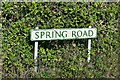
Spring Road by the footpath to the windmill
Image: © Adrian S Pye
Taken: 8 May 2015
0.17 miles
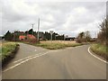
10
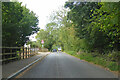
Spring Road, Bardwell
Heading north out of the village.
Image: © Robin Webster
Taken: 21 Aug 2022
0.17 miles