IMAGES TAKEN NEAR TO
Church Road, BURY ST. EDMUNDS, IP31 1AH
Introduction
This page details the photographs taken nearby to Church Road, IP31 1AH by members of the Geograph project.
The Geograph project started in 2005 with the aim of publishing, organising and preserving representative images for every square kilometre of Great Britain, Ireland and the Isle of Man.

There are currently over 7.5m images from over14,400 individuals and you can help contribute to the project by visiting https://www.geograph.org.uk
Image Map
Images are licensed for reuse under creativecommons.org/licenses/by-sa/2.0
Notes
- Clicking on the map will re-center to the selected point.
- The higher the marker number, the further away the image location is from the centre of the postcode.
Image Listing (93 Images Found)
Images are licensed for reuse under creativecommons.org/licenses/by-sa/2.0
Image
Details
Distance
1
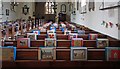
St Peter & St Paul, Bardwell - Hassocks
Image: © John Salmon
Taken: 30 Mar 2012
0.02 miles
2
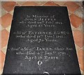
St Peter & St Paul, Bardwell - Ledger slab
Image: © John Salmon
Taken: 30 Mar 2012
0.02 miles
4
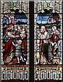
St Peter & St Paul, Bardwell - Stained glass window
Image: © John Salmon
Taken: 30 Mar 2012
0.02 miles
5
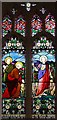
St Peter & St Paul, Bardwell - Stained glass window
Image: © John Salmon
Taken: 30 Mar 2012
0.02 miles
6
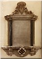
St Peter & St Paul, Bardwell - Wall monument
Image: © John Salmon
Taken: 30 Mar 2012
0.02 miles
7
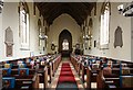
St Peter & St Paul, Bardwell - East end
Image: © John Salmon
Taken: 30 Mar 2012
0.02 miles
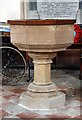
8
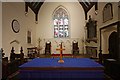
St Peter & St Paul, Bardwell - Sanctuary
Image: © John Salmon
Taken: 30 Mar 2012
0.02 miles
9
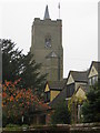
The Church Tower with its Spire of St Peter and St Paul at Bardwell
Viewed from the west.
Image: © Peter Wood
Taken: 14 Nov 2014
0.02 miles
10
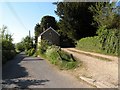
Church Road in Bardwell
The rough track on the right leads to the parish church.
Image: © Robert Edwards
Taken: 3 May 2011
0.03 miles