IMAGES TAKEN NEAR TO
Lee Road, IPSWICH, IP3 0PX
Introduction
This page details the photographs taken nearby to Lee Road, IP3 0PX by members of the Geograph project.
The Geograph project started in 2005 with the aim of publishing, organising and preserving representative images for every square kilometre of Great Britain, Ireland and the Isle of Man.

There are currently over 7.5m images from over14,400 individuals and you can help contribute to the project by visiting https://www.geograph.org.uk
Image Map
Images are licensed for reuse under creativecommons.org/licenses/by-sa/2.0
Notes
- Clicking on the map will re-center to the selected point.
- The higher the marker number, the further away the image location is from the centre of the postcode.
Image Listing (42 Images Found)
Images are licensed for reuse under creativecommons.org/licenses/by-sa/2.0
Image
Details
Distance
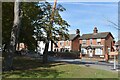
2
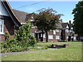
Almshouses, Cliff Lane
Erected in 1938, in memory of King George V.
Image: © Oxymoron
Taken: 18 May 2009
0.09 miles
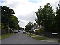
8
Victorian houses on Nacton Road
The houses were built on the northern side of Nacton Road near the junction with Clapgate Lane in the late 1800s and looked out over green fields until the construction of the Gainsborough Estate in the early 1930s.
Image: © Simon Mortimer
Taken: 10 Sep 2020
0.15 miles
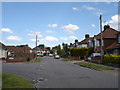
9
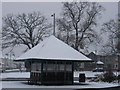
Bus shelter on the corner of Clapgate Lane and Nacton Road
Image: © Oxymoron
Taken: 2 Feb 2009
0.15 miles
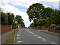
10
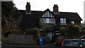
Houses, 1901
On the junction between Nacton and Felixstowe roads.
Image: © Oxymoron
Taken: 4 Feb 2009
0.16 miles