IMAGES TAKEN NEAR TO
Leighton Square, IPSWICH, IP3 0LL
Introduction
This page details the photographs taken nearby to Leighton Square, IP3 0LL by members of the Geograph project.
The Geograph project started in 2005 with the aim of publishing, organising and preserving representative images for every square kilometre of Great Britain, Ireland and the Isle of Man.

There are currently over 7.5m images from over14,400 individuals and you can help contribute to the project by visiting https://www.geograph.org.uk
Image Map
Images are licensed for reuse under creativecommons.org/licenses/by-sa/2.0
Notes
- Clicking on the map will re-center to the selected point.
- The higher the marker number, the further away the image location is from the centre of the postcode.
Image Listing (20 Images Found)
Images are licensed for reuse under creativecommons.org/licenses/by-sa/2.0
Image
Details
Distance
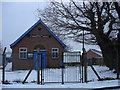
2
Evangelical Church
leighton road Evangelical church Ipswich Suffolk.
Image: © Keith Evans
Taken: 24 Nov 2006
0.05 miles
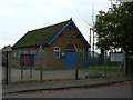
6
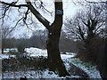
Strictly no camping or fires
Open land behind Morland Road
Image: © Oxymoron
Taken: 2 Feb 2009
0.15 miles
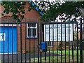
8
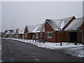
New bungalows along Morland Road
Compare the quality of these buildings with that of the older bungalows just a few metres further along the road http://www.geograph.org.uk/photo/1144269 .
Image: © Oxymoron
Taken: 2 Feb 2009
0.18 miles
9
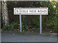
Cole Ness Road sign
On Cole Ness Road at the junction with Brazier's Wood Road
Image: © Geographer
Taken: 25 Sep 2014
0.19 miles
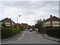
10
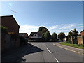
Brazier's Wood Road, Gainsburgh, Ipswich
At the junction with Cole Ness Road
Image: © Geographer
Taken: 25 Sep 2014
0.19 miles