IMAGES TAKEN NEAR TO
Tye Road, IPSWICH, IP3 0FL
Introduction
This page details the photographs taken nearby to Tye Road, IP3 0FL by members of the Geograph project.
The Geograph project started in 2005 with the aim of publishing, organising and preserving representative images for every square kilometre of Great Britain, Ireland and the Isle of Man.

There are currently over 7.5m images from over14,400 individuals and you can help contribute to the project by visiting https://www.geograph.org.uk
Image Map
Images are licensed for reuse under creativecommons.org/licenses/by-sa/2.0
Notes
- Clicking on the map will re-center to the selected point.
- The higher the marker number, the further away the image location is from the centre of the postcode.
Image Listing (147 Images Found)
Images are licensed for reuse under creativecommons.org/licenses/by-sa/2.0
Image
Details
Distance
2
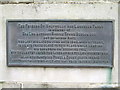
Exercise Foil
Plaque on the wall of Holywells Park Myrtle Road Ipswich Suffolk.
Image: © Keith Evans
Taken: 10 Jan 2009
0.06 miles
4
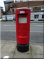
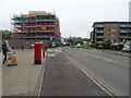
Elizabeth II postbox on Duke Street (B1358)
Postbox No.IP3 8252.
See Image] for context.
Image: © JThomas
Taken: 12 May 2023
0.09 miles
6
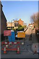
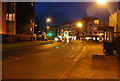
Duke Street (B1358)
Showing position of Postbox No.IP3 8252.
See Image] for postbox.
Image: © JThomas
Taken: 12 May 2023
0.10 miles
7
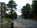
Myrtle Road
From the entrance to Holywells Park.
Image: © Hamish Griffin
Taken: 7 Mar 2021
0.10 miles
8
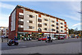
Devonshire Road, Ipswich
The steepest hill in the town, temporarily closed for resurfacing.
Image: © Bob Jones
Taken: 6 Dec 2006
0.10 miles
10
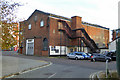
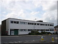
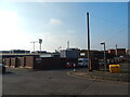
Former Ransomes building, Ipswich
The name may be made out below the circular feature on the gable end. Now used for at least a pool club and some sort of garage.
Image: © Robin Webster
Taken: 19 Nov 2017
0.11 miles