
IMAGES TAKEN NEAR TO
Dock Head, IPSWICH, IP3 0DP
Introduction
This page details the photographs taken nearby to Dock Head, IP3 0DP by members of the Geograph project.
The Geograph project started in 2005 with the aim of publishing, organising and preserving representative images for every square kilometre of Great Britain, Ireland and the Isle of Man.

There are currently over 7.5m images from over14,400 individuals and you can help contribute to the project by visiting https://www.geograph.org.uk
Image Map
Images are licensed for reuse under creativecommons.org/licenses/by-sa/2.0
Notes
- Clicking on the map will re-center to the selected point.
- The higher the marker number, the further away the image location is from the centre of the postcode.
Image Listing (134 Images Found)
Images are licensed for reuse under creativecommons.org/licenses/by-sa/2.0
Image
Details
Distance
1
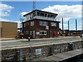
Control tower, Prince Philip Lock, Ipswich
The floating pontoon inside the lock is for smaller boats to tie up to.
Image: © Christine Johnstone
Taken: 12 Jul 2017
0.01 miles
2

Green light at Prince Philip Lock, Ipswich
The swingbridge across the lock has been opened to let boats through. Both top and bottom gates are open, as it is high tide and both the harbour and the estuary are at the same level.
Image: © Christine Johnstone
Taken: 12 Jul 2017
0.02 miles
3

Boats in Prince Philip Lock, Ipswich
Only the mast of the further boat is visible. The wet dock [floating harbour] is kept at the level of high tide, so when the tide has fallen, boats have to lock up into it.
Image: © Christine Johnstone
Taken: 12 Jul 2017
0.02 miles
4
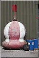
In need of a paint job
This navigation buoy stands outside a maintenance workshop at Ipswich Docks, awaiting a lick or two of paint.
Image: © Bob Jones
Taken: 3 Apr 2008
0.02 miles
5
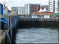
Prince Philip Lock, filling with water
The water is welling up from underwater sluices. The wet dock [floating harbour] is kept at the level of high tide, so when the tide has fallen, boats have to lock up into it.
Image: © Christine Johnstone
Taken: 12 Jul 2017
0.02 miles
6

Swing Bridge, Ipswich Dock Lock
This Swing bridge can swing over the lock on the right and carries road and rail traffic
Image: © Oxyman
Taken: 12 Jul 2007
0.02 miles
7

Swing bridge over entrance lock
This bridge swings horizontally through 90 degrees to allow vessels to pass through the lock. It is normally left in this position to permit vehicular traffic to cross. The building behind is the Orwell Navigation Service office, where radar and radio contact is maintained with vessels using the port.
Image: © Bob Jones
Taken: 3 Apr 2008
0.02 miles
8

Ipswich Dock Lock
This picture is taken from the southern lock gates which when closed form a footbridge across the water. On the left is a blue painted railway swing bridge that is able to swing across the water allowing trains to cross.
Image: © Oxyman
Taken: 12 Jul 2007
0.02 miles
9

New storm gates at lock entrance
As part of a major scheme to secure the town of Ipswich against flooding from a future storm surge, these new storm gates have been installed recently at Prince Philip Lock. Their height is more than a metre above the existing defences. Further improvements will include a flood barrier in the adjacent New Cut, which carries the tidal waters of the River Orwell.
Image: © Bob Jones
Taken: 11 Dec 2008
0.02 miles
10

Lock and swingbridge in the docks at Ipswich
Image: © Gareth James
Taken: 25 Jul 2021
0.02 miles