IMAGES TAKEN NEAR TO
Cliff Road, IPSWICH, IP3 0AT
Introduction
This page details the photographs taken nearby to Cliff Road, IP3 0AT by members of the Geograph project.
The Geograph project started in 2005 with the aim of publishing, organising and preserving representative images for every square kilometre of Great Britain, Ireland and the Isle of Man.

There are currently over 7.5m images from over14,400 individuals and you can help contribute to the project by visiting https://www.geograph.org.uk
Image Map
Images are licensed for reuse under creativecommons.org/licenses/by-sa/2.0
Notes
- Clicking on the map will re-center to the selected point.
- The higher the marker number, the further away the image location is from the centre of the postcode.
Image Listing (164 Images Found)
Images are licensed for reuse under creativecommons.org/licenses/by-sa/2.0
Image
Details
Distance
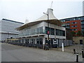
1
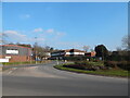
Roundabout
The exit in front is for Myrtle Road while the one on the left is Duke Street (B1458).
Image: © Hamish Griffin
Taken: 7 Mar 2021
0.04 miles
3
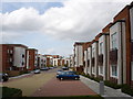
Housing on Maude Street, Ipswich
Looking at the back, the building looks more conventional on the other side.
Image: © Robin Webster
Taken: 19 Nov 2017
0.08 miles
4
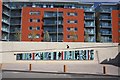
'Beyond the Horizon' mural, Ipswich Docks
This mural, created by Don Savage and unveiled in October 2007 by the Mayor of Ipswich, commemorates 400 years since the founding of Jamestown, Virginia. It brings together historical and contemporary references of a voyage that formed the basis of modern America. Suffolk-born Bartholomew Gosnold led the voyage, which suffered clashes with Indian tribes on its arrival and disease on the wet, mosquito-infested island. However, the Jamestown settlement survived and the introduction of tobacco as a commercial crop provided much of the economic basis for the settlement's survival. The mural is intended to be viewed both from the footpath and from boats as they approach and leave the port of Ipswich.
Image: © Bob Jones
Taken: 3 Apr 2008
0.09 miles
5
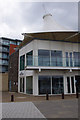
Aurora, Eagle Wharf
Quayside bar & restaurant. Also see Image
Image: © Ian Taylor
Taken: 24 Jun 2013
0.09 miles
7
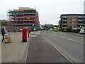
Duke Street (B1358)
Showing position of Postbox No.IP3 8252.
See Image] for postbox.
Image: © JThomas
Taken: 12 May 2023
0.10 miles
8
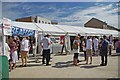
Ipswich Maritime (& Beer Festival )
The Ipswich Maritime Festival http://www.waterfrontaction.co.uk/MaritimeIpswich/default.html is amply supplied with food outlets for all tastes especially Real ale & Cider http://www.ipswichcamra.com/. The buildings in the background are part of University Campus Suffolk http://www.ucs.ac.uk/home.aspx take a look Image & Image
Image: © Glyn Baker
Taken: 20 Aug 2011
0.10 miles
9
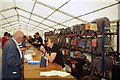
Inside Ipswich Beer Festival
One of two marquees supplying real ale and cider as well as a surprising interloper
see Image
Image: © Glyn Baker
Taken: 20 Aug 2011
0.10 miles
10
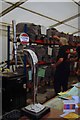
Not Real Ale!
Being part of the Ipswich Maritime festival Camra rules get slightly bent by supplying the needs of "lager boys" with craft products not made by the international giant lager factories.
Image: © Glyn Baker
Taken: 20 Aug 2011
0.10 miles