IMAGES TAKEN NEAR TO
The Battlies, IP30 9ZD
Introduction
This page details the photographs taken nearby to The Battlies, IP30 9ZD by members of the Geograph project.
The Geograph project started in 2005 with the aim of publishing, organising and preserving representative images for every square kilometre of Great Britain, Ireland and the Isle of Man.

There are currently over 7.5m images from over14,400 individuals and you can help contribute to the project by visiting https://www.geograph.org.uk
Image Map
Images are licensed for reuse under creativecommons.org/licenses/by-sa/2.0
Notes
- Clicking on the map will re-center to the selected point.
- The higher the marker number, the further away the image location is from the centre of the postcode.
Image Listing (27 Images Found)
Images are licensed for reuse under creativecommons.org/licenses/by-sa/2.0
Image
Details
Distance
1
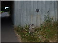
To Bury 3
Old milestone for what was the A45 in new location after road reconstruction see http://www.geograph.org.uk/photo/894356 for info on the plaque near to Bury St.Edmunds Suffolk. For more info on the post see http://milestones.megalithia.com/sites/missing.php?site_status=offmap&site_fb=1&site_ngr=TL899637&site_name=Rougham%20Estate&site_surveyed=2002 do look at their home page.
Image: © Keith Evans
Taken: 22 Jul 2008
0.06 miles
2
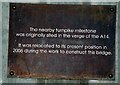
Information plaque
Information plaque for old milestone near to Bury St.Edmunds Suffolk. For view of the milestone see http://www.geograph.org.uk/photo/894349 For info on the post the plaque is referring to see http://milestones.megalithia.com/sites/missing.php?site_status=offmap&site_fb=1&site_ngr=TL899637&site_name=Rougham%20Estate&site_surveyed=2002 do look at their home page.
Image: © Keith Evans
Taken: 22 Jul 2008
0.06 miles
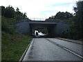
3
Underpass
Underpass of a local road under the A14 see http://www.geograph.org.uk/photo/29460 for the photo by Bob Jones of it being constructed in July 2005.
Image: © Keith Evans
Taken: 22 Jul 2008
0.08 miles
5
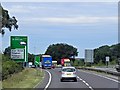
Westbound A14 Approaching Rookery Crossroads
Image: © David Dixon
Taken: 5 Aug 2013
0.09 miles
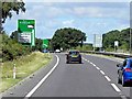
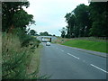
7
Eastbound A14 approaching Rookery Crossroads (Junction 45)
Image: © David Dixon
Taken: 1 Aug 2013
0.11 miles
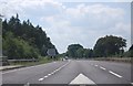
9
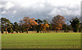
Fields and treeline at Blackthorpe
This line of trees, some displaying autumn colours, divide two arable fields north of the A14 at Blackthorpe.
Image: © Bob Jones
Taken: 23 Nov 2009
0.12 miles
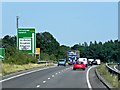
10
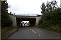
Blackthorpe Road, Rougham Heath
At the A14 Bridge near Rookery Crossroads junction
Image: © Geographer
Taken: 15 Sep 2017
0.13 miles