IMAGES TAKEN NEAR TO
Farrow Close, BURY ST. EDMUNDS, IP30 9YG
Introduction
This page details the photographs taken nearby to Farrow Close, IP30 9YG by members of the Geograph project.
The Geograph project started in 2005 with the aim of publishing, organising and preserving representative images for every square kilometre of Great Britain, Ireland and the Isle of Man.

There are currently over 7.5m images from over14,400 individuals and you can help contribute to the project by visiting https://www.geograph.org.uk
Image Map
Images are licensed for reuse under creativecommons.org/licenses/by-sa/2.0
Notes
- Clicking on the map will re-center to the selected point.
- The higher the marker number, the further away the image location is from the centre of the postcode.
Image Listing (19 Images Found)
Images are licensed for reuse under creativecommons.org/licenses/by-sa/2.0
Image
Details
Distance
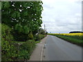
1
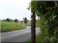
Entering Elmswell on Wetherden Road
At the entrance to Ekfield
Image: © Geographer
Taken: 25 May 2016
0.09 miles
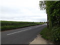
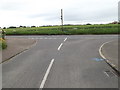
2
Wetherden Road, Elmswell
At the entrance to Ekfield
Image: © Geographer
Taken: 25 May 2016
0.09 miles
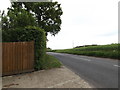
3
Wetherden Road, Elmswell
At the entrance to Ekfield
Image: © Geographer
Taken: 25 May 2016
0.09 miles
4
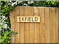
Ekfield sign
At the entrance to Ekfield off Wetherden Road
Image: © Geographer
Taken: 25 May 2016
0.09 miles
6
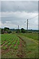
Footpath to Wetherden Road
North from Warren Mill House
Image: © John Myers
Taken: 28 May 2014
0.11 miles
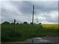
9
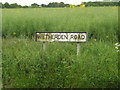
Wetherden Road sign
On Wetherden Road at the junction with Jubilee Terrace
Image: © Geographer
Taken: 25 May 2016
0.15 miles
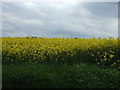
10
Jubilee Terrace, Elmswell
At the junction with Wetherden Road
Image: © Geographer
Taken: 25 May 2016
0.15 miles