IMAGES TAKEN NEAR TO
Rattlesden Road, BURY ST. EDMUNDS, IP30 9TN
Introduction
This page details the photographs taken nearby to Rattlesden Road, IP30 9TN by members of the Geograph project.
The Geograph project started in 2005 with the aim of publishing, organising and preserving representative images for every square kilometre of Great Britain, Ireland and the Isle of Man.

There are currently over 7.5m images from over14,400 individuals and you can help contribute to the project by visiting https://www.geograph.org.uk
Image Map
Images are licensed for reuse under creativecommons.org/licenses/by-sa/2.0
Notes
- Clicking on the map will re-center to the selected point.
- The higher the marker number, the further away the image location is from the centre of the postcode.
Image Listing (3 Images Found)
Images are licensed for reuse under creativecommons.org/licenses/by-sa/2.0
Image
Details
Distance
1
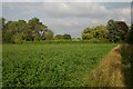
Clover field at Drinkstone Green
This field lies north of Garden House Lane.
Image: © Bob Jones
Taken: 23 Sep 2006
0.11 miles
2
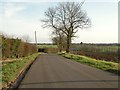
The road to Rattlesden from Drinkstone
Image: © Robert Edwards
Taken: 24 Feb 2011
0.18 miles
3

Distant Cyclist
Loan cyclist in the distance having just made the long climb up Rattlesden Road at Drinkstone, Suffolk.
Image: © Keith Evans
Taken: 4 Sep 2010
0.20 miles