IMAGES TAKEN NEAR TO
Wades Wood, BURY ST. EDMUNDS, IP30 9SF
Introduction
This page details the photographs taken nearby to Wades Wood, IP30 9SF by members of the Geograph project.
The Geograph project started in 2005 with the aim of publishing, organising and preserving representative images for every square kilometre of Great Britain, Ireland and the Isle of Man.

There are currently over 7.5m images from over14,400 individuals and you can help contribute to the project by visiting https://www.geograph.org.uk
Image Map
Images are licensed for reuse under creativecommons.org/licenses/by-sa/2.0
Notes
- Clicking on the map will re-center to the selected point.
- The higher the marker number, the further away the image location is from the centre of the postcode.
Image Listing (30 Images Found)
Images are licensed for reuse under creativecommons.org/licenses/by-sa/2.0
Image
Details
Distance
2
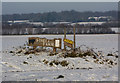
Open field with sign for Street Farm
Looking north from The Street at the edge of the village of Woolpit. Scene with lying snow.
Image: © Andrew Hill
Taken: 19 Dec 2009
0.06 miles
3
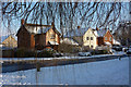
Modern houses at the edge of Woolpit
On The Street, with snow and weeping willow branches in the foreground.
Image: © Andrew Hill
Taken: 19 Dec 2009
0.10 miles
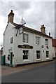
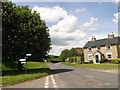
5
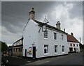
The Street, Woolpit
Looking south east towards the Bull public house.
Image: © JThomas
Taken: 14 Sep 2015
0.16 miles

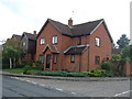
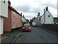
9
The Street, Woolpit, close to White Elm Road
Image: © Adrian S Pye
Taken: 30 May 2015
0.19 miles