IMAGES TAKEN NEAR TO
Woolpit, BURY ST. EDMUNDS, IP30 9RS
Introduction
This page details the photographs taken nearby to IP30 9RS by members of the Geograph project.
The Geograph project started in 2005 with the aim of publishing, organising and preserving representative images for every square kilometre of Great Britain, Ireland and the Isle of Man.

There are currently over 7.5m images from over14,400 individuals and you can help contribute to the project by visiting https://www.geograph.org.uk
Image Map
Images are licensed for reuse under creativecommons.org/licenses/by-sa/2.0
Notes
- Clicking on the map will re-center to the selected point.
- The higher the marker number, the further away the image location is from the centre of the postcode.
Image Listing (12 Images Found)
Images are licensed for reuse under creativecommons.org/licenses/by-sa/2.0
Image
Details
Distance
1

Elmswell, Warren Lane: The beginnings of a housing development
Image: © Michael Garlick
Taken: 5 Nov 2020
0.17 miles
2
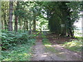
No Entry
No entry to the wood near to Borley Green, Suffolk.
Image: © Keith Evans
Taken: 9 Aug 2009
0.18 miles
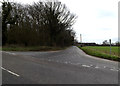
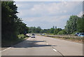
3
Former A14, Elmswell
At the junction with Warren Lane
Image: © Geographer
Taken: 22 Dec 2014
0.18 miles
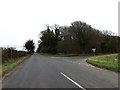
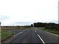
4
Warren Lane, Elmswell
At the junction with the former A14
Image: © Geographer
Taken: 22 Dec 2014
0.19 miles
7
Former A14, Elmswell
At the junction with Warren Lane
Image: © Geographer
Taken: 22 Dec 2014
0.22 miles
8

Warren Lane, Elmswell
At the junction with the former A14
Image: © Geographer
Taken: 22 Dec 2014
0.23 miles

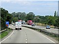
10
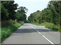
Old Road
This road was part of the old A.45 until the late 1970s when it was bypassed. The bypased A.45 has since been renumbered the A.14 in the early 1990s. Looking west near to Wetherden, Suffolk.
Image: © Keith Evans
Taken: 9 Aug 2009
0.24 miles