IMAGES TAKEN NEAR TO
Wood Close, BURY ST. EDMUNDS, IP30 9PX
Introduction
This page details the photographs taken nearby to Wood Close, IP30 9PX by members of the Geograph project.
The Geograph project started in 2005 with the aim of publishing, organising and preserving representative images for every square kilometre of Great Britain, Ireland and the Isle of Man.

There are currently over 7.5m images from over14,400 individuals and you can help contribute to the project by visiting https://www.geograph.org.uk
Image Map
Images are licensed for reuse under creativecommons.org/licenses/by-sa/2.0
Notes
- Clicking on the map will re-center to the selected point.
- The higher the marker number, the further away the image location is from the centre of the postcode.
Image Listing (9 Images Found)
Images are licensed for reuse under creativecommons.org/licenses/by-sa/2.0
Image
Details
Distance
1
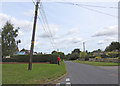
Telegraph pole under pressure in Tostock Street
Image: © Adrian S Pye
Taken: 21 Jul 2019
0.06 miles

4
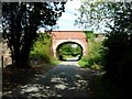
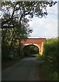
Railway Bridge north of Tostock
This bridge carries the Bury St Edmunds - Ipswich railway over the Tostock - Norton road.
Image: © Stephen McKay
Taken: 19 Aug 2006
0.17 miles
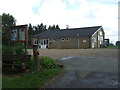
6
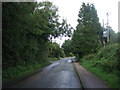
Pumping station on Norton Road, Tostock
Image: © Adrian S Pye
Taken: 21 Jul 2019
0.20 miles
7
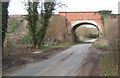
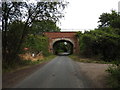
Railway bridge over Norton Road north of Tostock
Image: © Andrew Hill
Taken: 30 Mar 2008
0.20 miles