IMAGES TAKEN NEAR TO
Thurston Road, BURY ST. EDMUNDS, IP30 9LU
Introduction
This page details the photographs taken nearby to Thurston Road, IP30 9LU by members of the Geograph project.
The Geograph project started in 2005 with the aim of publishing, organising and preserving representative images for every square kilometre of Great Britain, Ireland and the Isle of Man.

There are currently over 7.5m images from over14,400 individuals and you can help contribute to the project by visiting https://www.geograph.org.uk
Image Map
Images are licensed for reuse under creativecommons.org/licenses/by-sa/2.0
Notes
- Clicking on the map will re-center to the selected point.
- The higher the marker number, the further away the image location is from the centre of the postcode.
Image Listing (7 Images Found)
Images are licensed for reuse under creativecommons.org/licenses/by-sa/2.0
Image
Details
Distance
1
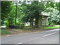
The Round House
The Round House near to Thurston, Suffolk.
Image: © Keith Evans
Taken: 31 Aug 2009
0.02 miles
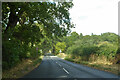
2
Thurston Road at Fishwick Corner
At the junction with New Road
Image: © Geographer
Taken: 15 Sep 2017
0.15 miles
3
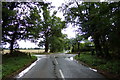
New Road at Fishwick Corner
At the junction with Thurston Road
Image: © Geographer
Taken: 15 Sep 2017
0.16 miles
4

Fishwick Corner sign on New Road
At the junction with Thurston Road
Image: © Geographer
Taken: 15 Sep 2017
0.16 miles
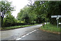
5
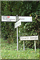
Roadsigns on New Road at Fishwick Corner
At the junction with Thurston Road
Image: © Geographer
Taken: 15 Sep 2017
0.17 miles
6

Newhall Covert
Sunlight shines through the ferns at Newhall Covert, near the minor road leading to Rougham.
Image: © Bob Jones
Taken: 22 Oct 2008
0.17 miles