IMAGES TAKEN NEAR TO
Smithy Close, BURY ST. EDMUNDS, IP30 9LA
Introduction
This page details the photographs taken nearby to Smithy Close, IP30 9LA by members of the Geograph project.
The Geograph project started in 2005 with the aim of publishing, organising and preserving representative images for every square kilometre of Great Britain, Ireland and the Isle of Man.

There are currently over 7.5m images from over14,400 individuals and you can help contribute to the project by visiting https://www.geograph.org.uk
Image Map
Images are licensed for reuse under creativecommons.org/licenses/by-sa/2.0
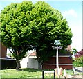
Notes
- Clicking on the map will re-center to the selected point.
- The higher the marker number, the further away the image location is from the centre of the postcode.
Image Listing (40 Images Found)
Images are licensed for reuse under creativecommons.org/licenses/by-sa/2.0
Image
Details
Distance
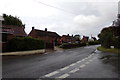
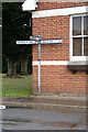
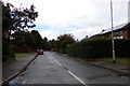
2
Kingshall Street, Rougham
At the junction with Moat Lane & Kingshall Street
Image: © Geographer
Taken: 15 Sep 2017
0.08 miles
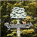
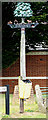
3
Rougham village sign
A three dimensional sign in steel showing deer, the church’s lychgate, a large oak tree and a man and horse ploughing. In holes on the cross-member are oak leaves and an anonymous pile of bricks.
https://www.geograph.org.uk/photo/6663359
Image: © Adrian S Pye
Taken: 3 Nov 2020
0.08 miles
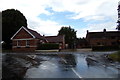
4
Moat Lane, Rougham
At the junction with Kingshall Street
Image: © Geographer
Taken: 15 Sep 2017
0.08 miles
5
Roadsign on Kingshall Street
At the junction with Moat Lane & Kingshall Street
Image: © Geographer
Taken: 15 Sep 2017
0.08 miles
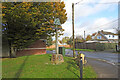
6
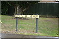
Kingshall Street sign
On Kingshall Street at the junction with Moat Lane & Kingshall Street
Image: © Geographer
Taken: 15 Sep 2017
0.08 miles
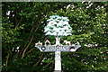
7
Rougham village sign
A three dimensional sign in steel showing deer, the church’s lychgate, a large oak tree and a man and horse ploughing. In holes on the cross-member are oak leaves and an anonymous pile of bricks.
https://www.geograph.org.uk/photo/6663360
Image: © Adrian S Pye
Taken: 3 Nov 2020
0.08 miles
8
Rougham Village sign
On Orchard Close at the junction with Kingshall Street
(Close up)
Image: © Geographer
Taken: 15 Sep 2017
0.08 miles
9
Rougham Village sign
On Orchard Close at the junction with Kingshall Street
Image: © Geographer
Taken: 15 Sep 2017
0.08 miles
10
Orchard Close, Rougham
At the junction with Kingshall Street
Image: © Geographer
Taken: 15 Sep 2017
0.09 miles