IMAGES TAKEN NEAR TO
Greencroft, BURY ST. EDMUNDS, IP30 9FP
Introduction
This page details the photographs taken nearby to Greencroft, IP30 9FP by members of the Geograph project.
The Geograph project started in 2005 with the aim of publishing, organising and preserving representative images for every square kilometre of Great Britain, Ireland and the Isle of Man.

There are currently over 7.5m images from over14,400 individuals and you can help contribute to the project by visiting https://www.geograph.org.uk
Image Map
Images are licensed for reuse under creativecommons.org/licenses/by-sa/2.0
Notes
- Clicking on the map will re-center to the selected point.
- The higher the marker number, the further away the image location is from the centre of the postcode.
Image Listing (13 Images Found)
Images are licensed for reuse under creativecommons.org/licenses/by-sa/2.0
Image
Details
Distance
1
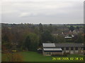
From St Mary's Church Tower, Woolpit
General View towards Woolpit Heath 130 SSE from top of Parish Church of Woolpit
Image: © Ian Lisseman
Taken: 29 Aug 2005
0.12 miles
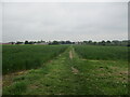
2
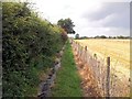
Footpath alongside a partially-harvested wheat field
Image: © Helen Steed
Taken: 2 Aug 2012
0.14 miles
3
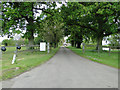
Green Road, Woolpit
Entering the village of Woolpit from the south.
Image: © Paul Franks
Taken: 14 Mar 2015
0.15 miles
5
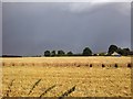
Storm clouds gather over partially-harvested wheat fields
If you look carefully, you can just see a rainbow.
Image: © Helen Steed
Taken: 2 Aug 2012
0.17 miles
6
Footpath to Woolpit from Woolpit Green
Image: © Jonathan Thacker
Taken: 16 May 2022
0.19 miles
8
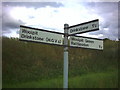
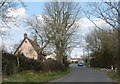
Road sign near Woolpit Green
The direct road to Drinkstone goes over a bridge with an 8 ton weight limit.
Image: © Noel Foster
Taken: 30 Jul 2005
0.21 miles
9
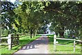
Grange Farm, Woolpit Green
This is also a farm shop and butchery.
Image: © Bob Jones
Taken: 23 Sep 2006
0.22 miles