IMAGES TAKEN NEAR TO
Valentine Way, BURY ST. EDMUNDS, IP30 9BP
Introduction
This page details the photographs taken nearby to Valentine Way, IP30 9BP by members of the Geograph project.
The Geograph project started in 2005 with the aim of publishing, organising and preserving representative images for every square kilometre of Great Britain, Ireland and the Isle of Man.

There are currently over 7.5m images from over14,400 individuals and you can help contribute to the project by visiting https://www.geograph.org.uk
Image Map
Images are licensed for reuse under creativecommons.org/licenses/by-sa/2.0
Notes
- Clicking on the map will re-center to the selected point.
- The higher the marker number, the further away the image location is from the centre of the postcode.
Image Listing (2 Images Found)
Images are licensed for reuse under creativecommons.org/licenses/by-sa/2.0
Image
Details
Distance
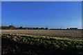
1
Footpath to Town Grove
This track is well used by farm vehicles but is also a public footpath. It starts at a small exclusive housing estate to the east of Hessett village.
Image: © Bob Jones
Taken: 20 Sep 2006
0.15 miles