IMAGES TAKEN NEAR TO
High Town Green, BURY ST. EDMUNDS, IP30 0SU

Introduction

This page details the photographs taken nearby to High Town Green, IP30 0SU by members of the Geograph project.

The Geograph project started in 2005 with the aim of publishing, organising and preserving representative images for every square kilometre of Great Britain, Ireland and the Isle of Man.

There are currently over 7.5m images from over14,400 individuals and you can help contribute to the project by visiting https://www.geograph.org.uk

Image Map


Images are licensed for reuse under creativecommons.org/licenses/by-sa/2.0
Notes
  • Clicking on the map will re-center to the selected point.
  • The higher the marker number, the further away the image location is from the centre of the postcode.

Image Listing (11 Images Found)

Images are licensed for reuse under creativecommons.org/licenses/by-sa/2.0
Image
Details
Distance
1
Location of the Rattlesden airfield memorial
Showing the proximity of the road to http://www.geograph.org.uk/photo/5519620 Click the link for details.
Image: © Adrian S Pye Taken: 31 Aug 2017
0.11 miles
2
Small lake at Kettles Farm Fishery
Image: © Andrew Hill Taken: 5 Jan 2008
0.12 miles
3
Field and line of trees north of Hightown Green
Image: © Andrew Hill Taken: 5 Jan 2008
0.12 miles
4
War Memorial
In memory of those who died during World War 2
Image: © Robert Edwards Taken: 3 Nov 2006
0.12 miles
5
WW2 Memorial to 447th Bomb Group
Image: © Helen Steed Taken: 30 Jul 2012
0.12 miles
6
Rattlesden Airfield Memorial
Rattlesden airfield was built in 1942 as a Class A bomber airfield. The airfield had three intersecting concrete runways, perimeter track and, for USAAF use, hardstands for fifty aircraft and two T-2 hangars. Living and messing sites were on the east side of the airfield. The airfield was opened in 1942 and had the designation 126(RS). Rattlesden was originally designated as a satellite for RAF Bury St. Edmunds with both airfields being assigned to the 3rd Bomb Wing. The 447th Bombardment Group (Heavy) arrived from Harvard AAF Nebraska on 29 November 1943. The 447th was assigned a group tail code was a "Square-K". It is for the 477th that the station is best and most fondly remembered.
Image: © Adrian S Pye Taken: 31 Aug 2017
0.12 miles
7
Rattlesden Airfield Memorial
Rattlesden airfield was built in 1942 as a Class A bomber airfield. The airfield had three intersecting concrete runways, perimeter track and, for USAAF use, hardstands for fifty aircraft and two T-2 hangars. Living and messing sites were on the east side of the airfield. The airfield was opened in 1942 and had the designation 126(RS). Rattlesden was originally designated as a satellite for RAF Bury St. Edmunds with both airfields being assigned to the 3rd Bomb Wing. The 447th Bombardment Group (Heavy) arrived from Harvard AAF Nebraska on 29 November 1943. The 447th was assigned a group tail code was a "Square-K". It is for the 477th that the station is best and most fondly remembered.
Image: © Adrian S Pye Taken: 31 Aug 2017
0.13 miles
8
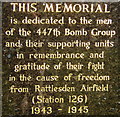
Memorial inscription
Image: © Andrew Hill Taken: 5 Jan 2008
0.14 miles
9
Setting of roadside memorial near Rattlesden Airfield
Image: © Andrew Hill Taken: 5 Jan 2008
0.14 miles
10
War memorial to US forces
This roadside memorial at Hightown Green commemorates members of the US Air Force 447th Bomb Group who were based at nearby Rattlesden Airfield between 1943 and 1945.
Image: © Bob Jones Taken: 1 Sep 2009
0.15 miles