IMAGES TAKEN NEAR TO
Brettenham Road, BURY ST. EDMUNDS, IP30 0SH
Introduction
This page details the photographs taken nearby to Brettenham Road, IP30 0SH by members of the Geograph project.
The Geograph project started in 2005 with the aim of publishing, organising and preserving representative images for every square kilometre of Great Britain, Ireland and the Isle of Man.

There are currently over 7.5m images from over14,400 individuals and you can help contribute to the project by visiting https://www.geograph.org.uk
Image Map
Images are licensed for reuse under creativecommons.org/licenses/by-sa/2.0
Notes
- Clicking on the map will re-center to the selected point.
- The higher the marker number, the further away the image location is from the centre of the postcode.
Image Listing (8 Images Found)
Images are licensed for reuse under creativecommons.org/licenses/by-sa/2.0
Image
Details
Distance
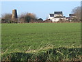
2
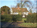
Hitchcock's Tower Mill, Rattlesden
This disused tower mill in Mill Lane, Rattlesden, is viewed across fields from a minor road.
Image: © Bob Jones
Taken: 1 Sep 2009
0.10 miles
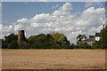
3
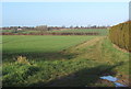
Fields southwest of Rattlesden, looking north
A footpath runs beside the hedge.
Image: © Andrew Hill
Taken: 5 Jan 2008
0.16 miles
4
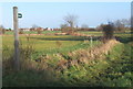
Start of footpath near Brook Farm
The distant buildings are in the next square east.
Image: © Andrew Hill
Taken: 5 Jan 2008
0.17 miles
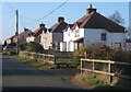
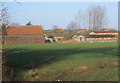
6
Brook Farm, in the northeast corner of the square
Image: © Andrew Hill
Taken: 5 Jan 2008
0.22 miles