IMAGES TAKEN NEAR TO
Woolpit Road, BURY ST. EDMUNDS, IP30 0RZ
Introduction
This page details the photographs taken nearby to Woolpit Road, IP30 0RZ by members of the Geograph project.
The Geograph project started in 2005 with the aim of publishing, organising and preserving representative images for every square kilometre of Great Britain, Ireland and the Isle of Man.

There are currently over 7.5m images from over14,400 individuals and you can help contribute to the project by visiting https://www.geograph.org.uk
Image Map
Images are licensed for reuse under creativecommons.org/licenses/by-sa/2.0
Notes
- Clicking on the map will re-center to the selected point.
- The higher the marker number, the further away the image location is from the centre of the postcode.
Image Listing (12 Images Found)
Images are licensed for reuse under creativecommons.org/licenses/by-sa/2.0
Image
Details
Distance
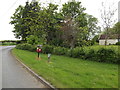
2

The Green & Clopton Green Postbox
Near Corner Farm
Postbox No.IP30 2144
Image: © Geographer
Taken: 25 May 2016
0.02 miles
3

Clopton Green Postbox
On The Green near Corner Farm
Postbox No.IP30 2144
Image: © Geographer
Taken: 25 May 2016
0.02 miles
4
Clopton Green Postbox
On The Green near Corner Farm
Postbox No.IP30 2144
Image: © Geographer
Taken: 25 May 2016
0.02 miles
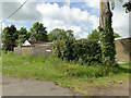
5
The Green, Clopton Green
Near Corner Farm
Image: © Geographer
Taken: 25 May 2016
0.02 miles


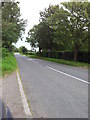
8
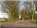
The approach to Clopton Green Farm and Hall
Image: © Robert Edwards
Taken: 24 Feb 2011
0.07 miles
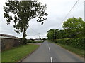
9
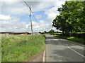
Road past Corner and Smallholding on the left
Image: © Adrian S Pye
Taken: 1 Jun 2015
0.09 miles