IMAGES TAKEN NEAR TO
Rattlesden, BURY ST. EDMUNDS, IP30 0RP
Introduction
This page details the photographs taken nearby to IP30 0RP by members of the Geograph project.
The Geograph project started in 2005 with the aim of publishing, organising and preserving representative images for every square kilometre of Great Britain, Ireland and the Isle of Man.

There are currently over 7.5m images from over14,400 individuals and you can help contribute to the project by visiting https://www.geograph.org.uk
Image Map
Images are licensed for reuse under creativecommons.org/licenses/by-sa/2.0
Notes
- Clicking on the map will re-center to the selected point.
- The higher the marker number, the further away the image location is from the centre of the postcode.
Image Listing (5 Images Found)
Images are licensed for reuse under creativecommons.org/licenses/by-sa/2.0
Image
Details
Distance
1
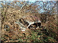
Rusty Car
An old dumped rusty car found half way down Gipsy lane near to Rattlesden Suffolk. See other view http://www.geograph.org.uk/photo/291631
Image: © Keith Evans
Taken: 9 Dec 2006
0.10 miles
2
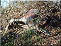
Rusty Car
Another view of an old dumped rusty car found half way down Gipsy lane near to Rattlesden Suffolk.
http://www.geograph.org.uk/photo/291623
Image: © Keith Evans
Taken: 9 Dec 2006
0.10 miles
3
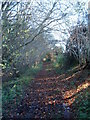
Gipsy Lane
Looking west along Gipsy lane near Rattlesden Suffolk.
Image: © Keith Evans
Taken: 9 Dec 2006
0.14 miles
4
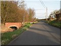
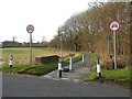
Stowmarket Road, heading towards Buxhall
Rattlesden River runs under the small bridge on the left.
Image: © Robert Edwards
Taken: 24 Feb 2011
0.19 miles
5
A public right of way between Rattlesden and Buxhall
The O/S map shows this path as having the name Back Road.
Image: © Robert Edwards
Taken: 24 Feb 2011
0.19 miles