IMAGES TAKEN NEAR TO
Felsham, BURY ST. EDMUNDS, IP30 0QN
Introduction
This page details the photographs taken nearby to IP30 0QN by members of the Geograph project.
The Geograph project started in 2005 with the aim of publishing, organising and preserving representative images for every square kilometre of Great Britain, Ireland and the Isle of Man.

There are currently over 7.5m images from over14,400 individuals and you can help contribute to the project by visiting https://www.geograph.org.uk
Image Map
Images are licensed for reuse under creativecommons.org/licenses/by-sa/2.0
Notes
- Clicking on the map will re-center to the selected point.
- The higher the marker number, the further away the image location is from the centre of the postcode.
Image Listing (7 Images Found)
Images are licensed for reuse under creativecommons.org/licenses/by-sa/2.0
Image
Details
Distance
1
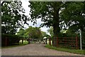
Felsham: Public footpath leading past Felsham Hall
Image: © Michael Garlick
Taken: 11 Jul 2020
0.04 miles
2
Footpath to Bradfield Woods
This path leads westwards from Cockfield Road. The woodland borders Felsham Hall.
Image: © Bob Jones
Taken: 18 Aug 2009
0.07 miles
3
Felsham: Concrete road to Hall Cottage
Image: © Michael Garlick
Taken: 11 Jul 2020
0.07 miles
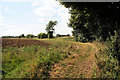
4
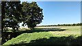
Farmland near Felsham
Looking south-eastwards from Cockfield Road, across a recently harvested field.
Image: © Bob Jones
Taken: 18 Aug 2009
0.15 miles
5
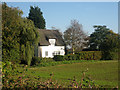
Thatched cottage
A thatched cottage tucked away, just off the road into Felsham.
Image: © Roger Temple
Taken: 4 Nov 2006
0.18 miles
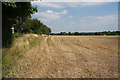
6
Footpath and Open Fields, North of Felsham
Image: © Stuart Shepherd
Taken: 27 Sep 2018
0.22 miles
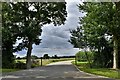
7
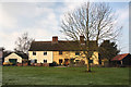
Houses on Felsham Green
The Green at Felsham is a triangle, formed by three roads. This view westwards is from the road that leads to Smallwood Green and Hessett.
Image: © Bob Jones
Taken: 15 Dec 2009
0.23 miles