IMAGES TAKEN NEAR TO
Thorpe Morieux, BURY ST. EDMUNDS, IP30 0NL
Introduction
This page details the photographs taken nearby to IP30 0NL by members of the Geograph project.
The Geograph project started in 2005 with the aim of publishing, organising and preserving representative images for every square kilometre of Great Britain, Ireland and the Isle of Man.

There are currently over 7.5m images from over14,400 individuals and you can help contribute to the project by visiting https://www.geograph.org.uk
Image Map
Images are licensed for reuse under creativecommons.org/licenses/by-sa/2.0
Notes
- Clicking on the map will re-center to the selected point.
- The higher the marker number, the further away the image location is from the centre of the postcode.
Image Listing (10 Images Found)
Images are licensed for reuse under creativecommons.org/licenses/by-sa/2.0
Image
Details
Distance
1
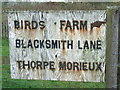
Sign
Sign at the start of Blacksmith Lane, Thorpe Morieux, Suffolk.
Image: © Keith Evans
Taken: 22 Jan 2012
0.05 miles
2
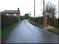
Blacksmith Lane
Blacksmith Thorpe Morieux, Suffolk.
Image: © Keith Evans
Taken: 22 Jan 2012
0.07 miles
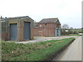
5
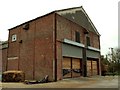
Farm building at The Wash
The O/S map calls this spot The Wash. Not sure which farm this building belongs to.
Image: © Robert Edwards
Taken: 1 Nov 2006
0.15 miles
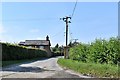
6
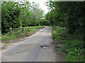
Bridge over the River Brett, Thorpe Morieux
A small bridge on this rural road near The Wash in Thorpe Morieux.
Image: © Roger Jones
Taken: 26 May 2014
0.17 miles
7
Small bridge over stream, near New Cottages, Thorpe Morieux
Image: © Roger Jones
Taken: 26 May 2014
0.20 miles
8
Farm buildings and propane tanks near to The Wash
Image: © Bikeboy
Taken: 29 May 2014
0.21 miles
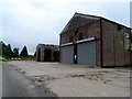
9
Farm Buildings
Farm buildings at The Wash near to Thorpe Morieux, Suffolk.
Image: © Keith Evans
Taken: 6 Mar 2011
0.22 miles
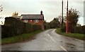
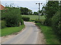
10
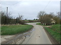
Road Junction Ahead
Road junction near to Thorpe Morieux, Suffolk.
Image: © Keith Evans
Taken: 6 Mar 2011
0.25 miles