IMAGES TAKEN NEAR TO
Bradfield Combust, BURY ST. EDMUNDS, IP30 0LS
Introduction
This page details the photographs taken nearby to IP30 0LS by members of the Geograph project.
The Geograph project started in 2005 with the aim of publishing, organising and preserving representative images for every square kilometre of Great Britain, Ireland and the Isle of Man.

There are currently over 7.5m images from over14,400 individuals and you can help contribute to the project by visiting https://www.geograph.org.uk
Image Map
Images are licensed for reuse under creativecommons.org/licenses/by-sa/2.0
Notes
- Clicking on the map will re-center to the selected point.
- The higher the marker number, the further away the image location is from the centre of the postcode.
Image Listing (14 Images Found)
Images are licensed for reuse under creativecommons.org/licenses/by-sa/2.0
Image
Details
Distance
1
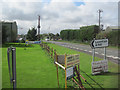
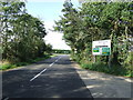
A134 looking south from Cross Green Junction
Image: © John Firth
Taken: 16 Sep 2010
0.01 miles
3
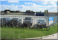
Haulage yard on A134 south of A 1141 junction
Image: © John Firth
Taken: 17 Sep 2010
0.02 miles
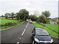
5
Near The Junction
The road junction of the A.134 and A.1141 near to Stanningfield, Suffolk.
Image: © Keith Evans
Taken: 25 Sep 2011
0.10 miles

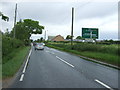
7

A134 towards Bury St Edmunds
Looking north east.
Image: © JThomas
Taken: 20 May 2017
0.17 miles
8

A134 towards Bury St Edmunds
Looking north at the junction with Chapel Road.
Image: © JThomas
Taken: 20 May 2017
0.18 miles
9
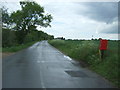
Chapel Road towards Hoggard's Green
Showing position of Postbox No. IP30 2140.
See Image] for postbox.
Image: © JThomas
Taken: 20 May 2017
0.18 miles
10
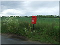
Elizabeth II postbox on Chapel Road
Image: © JThomas
Taken: 20 May 2017
0.18 miles