
IMAGES TAKEN NEAR TO
Old Hall Lane, BURY ST. EDMUNDS, IP30 0LQ
Introduction
This page details the photographs taken nearby to Old Hall Lane, IP30 0LQ by members of the Geograph project.
The Geograph project started in 2005 with the aim of publishing, organising and preserving representative images for every square kilometre of Great Britain, Ireland and the Isle of Man.

There are currently over 7.5m images from over14,400 individuals and you can help contribute to the project by visiting https://www.geograph.org.uk
Image Map
Images are licensed for reuse under creativecommons.org/licenses/by-sa/2.0
Notes
- Clicking on the map will re-center to the selected point.
- The higher the marker number, the further away the image location is from the centre of the postcode.
Image Listing (3 Images Found)
Images are licensed for reuse under creativecommons.org/licenses/by-sa/2.0
Image
Details
Distance
1
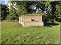
Hexagonal pillbox in Old Hall Lane, Cockfield
The pillbox is similar to a type FW3/22 but has the additional entrance porch instead of the normal doorway. One of many in the area on the Eastern Command Stop-line which stretched from Sutton on The Wash to Colchester and the coast.
Image: © Adrian S Pye
Taken: 7 Oct 2014
0.08 miles
2
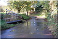
Cross Green Ford
This pretty irish bridge ford is found in Cross Green.
Image: © John Walton
Taken: 8 Nov 2012
0.16 miles
3
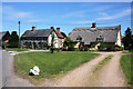
Cross Green, Cockfield
The large parish of Cockfield consists of nine hamlets, eight of which are 'greens', of which this is one. The others are Windsor, Colchester, Great, Old Hall, Button's, Parsonage and Smithwood. These cottages border the A1141.
Image: © Bob Jones
Taken: 27 Jun 2008
0.24 miles