IMAGES TAKEN NEAR TO
Smithwood Green, BURY ST. EDMUNDS, IP30 0JQ
Introduction
This page details the photographs taken nearby to Smithwood Green, IP30 0JQ by members of the Geograph project.
The Geograph project started in 2005 with the aim of publishing, organising and preserving representative images for every square kilometre of Great Britain, Ireland and the Isle of Man.

There are currently over 7.5m images from over14,400 individuals and you can help contribute to the project by visiting https://www.geograph.org.uk
Image Map
Images are licensed for reuse under creativecommons.org/licenses/by-sa/2.0
Notes
- Clicking on the map will re-center to the selected point.
- The higher the marker number, the further away the image location is from the centre of the postcode.
Image Listing (6 Images Found)
Images are licensed for reuse under creativecommons.org/licenses/by-sa/2.0
Image
Details
Distance
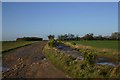
2
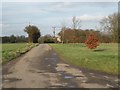
Cockfield: The acute bend in Gallow Lane
Image: © Michael Garlick
Taken: 11 Jul 2020
0.07 miles
3
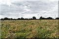
Cockfield: Small part of a huge area set aside for nature
Image: © Michael Garlick
Taken: 11 Jul 2020
0.11 miles
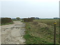
4
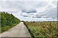
Cockfield: Public footpath/farm track
Image: © Michael Garlick
Taken: 11 Jul 2020
0.12 miles
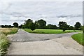
5
Bridleway at Smithwood Green
This bridleway leads to the A143 at Lawshall Green.
Image: © Bob Jones
Taken: 29 Nov 2006
0.14 miles
6
A Small Part
A small part of the former U.S.A.A.F Lavenham WWII airfield near to Cockfield, Suffolk.
Image: © Keith Evans
Taken: 20 Mar 2011
0.17 miles