IMAGES TAKEN NEAR TO
Cockfield, BURY ST. EDMUNDS, IP30 0JP
Introduction
This page details the photographs taken nearby to IP30 0JP by members of the Geograph project.
The Geograph project started in 2005 with the aim of publishing, organising and preserving representative images for every square kilometre of Great Britain, Ireland and the Isle of Man.

There are currently over 7.5m images from over14,400 individuals and you can help contribute to the project by visiting https://www.geograph.org.uk
Image Map
Images are licensed for reuse under creativecommons.org/licenses/by-sa/2.0
Notes
- Clicking on the map will re-center to the selected point.
- The higher the marker number, the further away the image location is from the centre of the postcode.
Image Listing (8 Images Found)
Images are licensed for reuse under creativecommons.org/licenses/by-sa/2.0
Image
Details
Distance
1
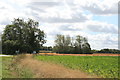
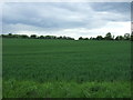
Farmland at Warbanks Farm
Looking south from beside the A134.
Image: © Paul Franks
Taken: 2 Sep 2019
0.05 miles

4
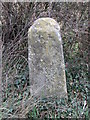
Old Milestone
Old milestone on the A.134 near to Lawshall, Suffolk. For overall view see http://www.geograph.org.uk/photo/1788413
Image: © Keith Evans
Taken: 5 Apr 2010
0.10 miles
5
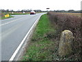
Bury To Sudbury
Old milestone on the A.134 near to Lawshall, Suffolk. For close up view see http://www.geograph.org.uk/photo/1788422
Image: © Keith Evans
Taken: 5 Apr 2010
0.10 miles
6

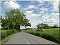
A134 towards Bury St Edmunds
Looking north west.
Image: © JThomas
Taken: 20 May 2017
0.11 miles
8

A134 looking north
A route from Colchester to King's Lynn, next major place, Bury St Edmunds.
Image: © Robin Webster
Taken: 21 Aug 2022
0.13 miles