IMAGES TAKEN NEAR TO
Cockfield, BURY ST. EDMUNDS, IP30 0JL
Introduction
This page details the photographs taken nearby to IP30 0JL by members of the Geograph project.
The Geograph project started in 2005 with the aim of publishing, organising and preserving representative images for every square kilometre of Great Britain, Ireland and the Isle of Man.

There are currently over 7.5m images from over14,400 individuals and you can help contribute to the project by visiting https://www.geograph.org.uk
Image Map
Images are licensed for reuse under creativecommons.org/licenses/by-sa/2.0
Notes
- Clicking on the map will re-center to the selected point.
- The higher the marker number, the further away the image location is from the centre of the postcode.
Image Listing (6 Images Found)
Images are licensed for reuse under creativecommons.org/licenses/by-sa/2.0
Image
Details
Distance
1
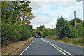
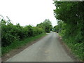
A134 looking north
A route from Colchester to King's Lynn, next major place, Bury St Edmunds.
Image: © Robin Webster
Taken: 21 Aug 2022
0.04 miles
2
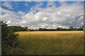
Midway Farm
This farm on the A134 is a mile north of the village of Alpheton. This view is taken from the Old Bury Road, now by-passed.
Image: © Bob Jones
Taken: 9 Jul 2006
0.10 miles
3
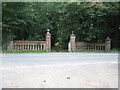
Nice Entrance
Entrance to Thorne Court of the A.134 near to Shimpling Street, Suffolk.
Image: © Keith Evans
Taken: 25 Sep 2011
0.20 miles
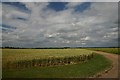
4
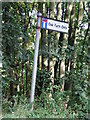
Farm Only
Dead end Oak Farm Only near to Lawshall, Suffolk.
Image: © Keith Evans
Taken: 25 Sep 2011
0.20 miles
5
Old Bury Road
Looking South along the Old Bury Road that was part of the A.134 until bypassed due to the construction of an airfield during WWII near to Alpheton, Suffolk.
Image: © Keith Evans
Taken: 5 May 2011
0.21 miles
6
Track to Oak Farm
This private track starts at the end of a no through road from the A134. The Anglian Trailer Centre is based at Oak Farm.
Image: © Bob Jones
Taken: 9 Jul 2006
0.21 miles