IMAGES TAKEN NEAR TO
Stows Hill, BURY ST. EDMUNDS, IP30 0JB
Introduction
This page details the photographs taken nearby to Stows Hill, IP30 0JB by members of the Geograph project.
The Geograph project started in 2005 with the aim of publishing, organising and preserving representative images for every square kilometre of Great Britain, Ireland and the Isle of Man.

There are currently over 7.5m images from over14,400 individuals and you can help contribute to the project by visiting https://www.geograph.org.uk
Image Map
Images are licensed for reuse under creativecommons.org/licenses/by-sa/2.0
Notes
- Clicking on the map will re-center to the selected point.
- The higher the marker number, the further away the image location is from the centre of the postcode.
Image Listing (8 Images Found)
Images are licensed for reuse under creativecommons.org/licenses/by-sa/2.0
Image
Details
Distance
2
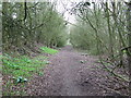
Old Trackbed
The old track bed of the Bury St. Edmunds to Lavenham railway line near to Cockfield, Suffolk.
Image: © Keith Evans
Taken: 20 Mar 2011
0.15 miles
3
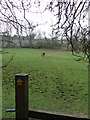
Green Field
Footpath through a green field near to Cockfield, Suffolk.
Image: © Keith Evans
Taken: 20 Mar 2011
0.17 miles
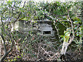
4
Pillbox on the railway embankment
The type FW3/22 variant pillbox has low entrance which is blocked by a tree growing between the pillbox and the blast wall. Inside there is a 'T' shaped anti-ricochet wall cum roof support. http://www.geograph.org.uk/photo/4196602
Image: © Adrian S Pye
Taken: 7 Oct 2014
0.19 miles
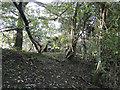
5
Pillbox on the railway embankment
Totally overgrown and difficult to find. http://www.geograph.org.uk/photo/4196600
Image: © Adrian S Pye
Taken: 7 Oct 2014
0.19 miles
6
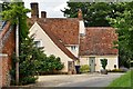
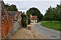
Cockfield, Clipt Bushes Farm: The farmhouse
Image: © Michael Garlick
Taken: 11 Jul 2020
0.22 miles