IMAGES TAKEN NEAR TO
Felsham Road, BURY ST. EDMUNDS, IP30 0AG
Introduction
This page details the photographs taken nearby to Felsham Road, IP30 0AG by members of the Geograph project.
The Geograph project started in 2005 with the aim of publishing, organising and preserving representative images for every square kilometre of Great Britain, Ireland and the Isle of Man.

There are currently over 7.5m images from over14,400 individuals and you can help contribute to the project by visiting https://www.geograph.org.uk
Image Map
Images are licensed for reuse under creativecommons.org/licenses/by-sa/2.0
Notes
- Clicking on the map will re-center to the selected point.
- The higher the marker number, the further away the image location is from the centre of the postcode.
Image Listing (8 Images Found)
Images are licensed for reuse under creativecommons.org/licenses/by-sa/2.0
Image
Details
Distance
1
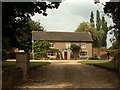
Farmhouse at Cargate Farm, near Felsham, Suffolk
Image: © Robert Edwards
Taken: 16 Aug 2006
0.05 miles
2
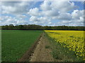
Footpath from Cargate to Monkspark Wood
Image: © Stuart Shepherd
Taken: 27 Sep 2018
0.11 miles
6
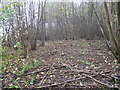
Coppicing in progress
The wood is managed on a 25 year coppice cycle. This was taken during a tea break, hence no people actually working! All the wood cut is used to make products from logs to thatching pegs which are sold to help the Suffolk Wildlife Trust. It is estimated that the wood has been continually under coppice management for at least 300 years.
Image: © Geoff Harris
Taken: 31 Oct 2009
0.23 miles
7
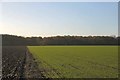
Footpath to Monkspark Wood
Monkspark Wood is part of Bradfield Woods, a National Nature Reserve.
Image: © Bob Jones
Taken: 29 Nov 2006
0.24 miles